 |
| This may be the lark I was talking about |
I work in the theatre. I do set design, lighting design and sometimes costume design, Usually not all at once. Currently I am designing lights for CATS so I don't have a lot of time for getting out and doing a lot of outdoorsy stuff. But last Thursday I had a short break because it was a tech rehearsal for sound only and my stuff wasn't being looked at and I couldn't be in the theatre working whilst they were doing their stuff. So I had about four hours to myself that I wasn't expecting.
I came home and announced to the Hot Chick that I was home for the evening but had to go back at about eleven pm for focusing and that I wanted to go out and do something with her. She hadn't been expecting to see me for days (because that's the way technical theatre is) so she had already made plans. I asked my boys if they wanted to do something, but they had already made plans too. They know the drill when I'm working on a show.
So, on a lark, I decided to drive out to Camas Wildlife Management Area by myself and hang out with those friends. I had already been to Camas WMA three times this season, but I believe that if a thing is worth doing it is worth overdoing. I headed out to Hamer, Idaho which is where the Camas WMA is located. It's about twenty minutes to the WMA from my home. When I got to Camas, I turned the radio in my car off so as not to frighten the birds and I entered my own private Idaho. From the time I entered Camas til the time I left, I didn't see another human being besides myself.
Camas WMA is a drive through wetlands. I am not sure if they are natural wetlands or if they have been engineered. If they are natural wetlands, there has been a little engineering done to them. The road is on a dike between ponds and steppe. At one time this was a ranch though. That much I know. It is possible that the ponds were put in a hundred years ago for watering livestock. I have seen that at other WMA's. Sand Creek WMA is a former ranch with ponds created for livestock a hundred years ago, for example.
If you follow the designated route at Camas, you get steppe on the right side of the car and wetlands on the left. Basically that means you get waterfowl on the left and raptors on the right. There's probably a political metaphor there, but I don't wish to explore that right now.
 |
| First animal I saw |
 |
| Showy Milkweed lined the canal banks in the first section of the WMA |
The first section of the drive was pretty uneventful. It was pleasant but nothing really spectacular. There were water birds on the ponds but they were far away and I don't have a big enough lens to get good shots of them. Over the steppe there were lots of raptors flying. Mostly hawks but I think I saw a peregrine falcon dart overhead. Once again, I didn't have a big enough lens to get good shots of them. I have a friend at the library who says when you see something you can't photograph you have to take a heart shot of it. So I did that.
I did see three raptors fighting mid-air over a mouse, though. That was cool. I took some pics but the birds were too far away and my 250mm zoom was too small to capture them. Don't get me wrong, I love my 250mm zoom lens. It's awesome and I use it all the time. Great lens. To get some of the shots I wanted at Camas last Thursday, though I would have needed a 400mm or a 600mm lens. At that point, though, I have to decide if I'm becoming a professional photographer or if I am content to stay an amateur photographer. Professional photography sounds like a job to me. Not sure if I want another one of those. I like the one I've got.
 |
| Raptor in flight |
 |
| The first big pond. One of these days I'll learn the names of the ponds. That would probably help |
 |
| Coot |
 |
| Don't remember what kind of duck or other waterbird this is |
 |
| Raptors fighting over a kill. This illustrates the limitations of my 250mm lens. It's a cool shot, but I had to crop it a great deal to get this image |
 |
| Third bird coming in for the prey |
 |
| Pretty cool shot nevertheless |
Then it started to get more interesting. I rounded the bend and came across a couple of sandhill cranes. I think cranes are elegant birds and I love to watch them. Then I saw a porcupine right at the side of the road. I hung out with him for awhile. I put the zoom right at 250mm and got as close as I could without scaring him (or her as the case might have been, didn't get close enough to find out) and snapped a lot of pictures. After awhile he became aware of me and I left. I want to view the animals, I don't want to scare them.
Then came owl time. I've always liked owls but hadn't seen very many of them in my life until I started hanging out at WMA's. Turns out if you want to see owls you have to go to where they are. They are mesmerizing.
At the last major pond, I saw black-necked stilts, which I had never seen before. They were really interesting. I think they fall under the category of wading birds. They have black and white plumage with long, pink legs. Great color combo for a designer.
On the way out of the WMA I saw a couple of whitetail deer and a great blue heron in the distance. Still waiting for the iconic great blue heron picture. I'll have to be satisfied with distance shots for awhile longer.
 |
| Sandhill cranes doing |
 |
| what sandhill cranes do |
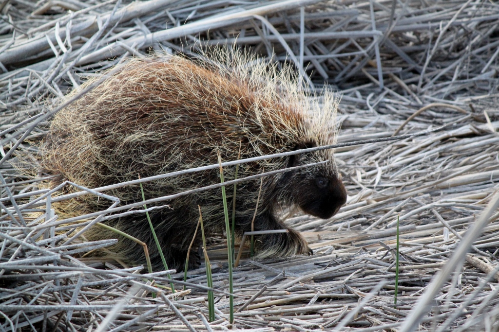 |
| The porcupine, trying to make a living |
 |
| Minding his own business |
 |
| At one point he shook himself out. I wonder if he was getting his quills ready. Dunno |
 |
| Doing his thing |
 |
| I think he became aware of me here |
 |
| So I left and he left. They can move quite fast |
 |
| And he hid with his tail hanging out of the culvert. I didn't stick around for any more shots of him. I think I had worn out my welcome at this point. |
 |
| Owl in flight |
 |
| again |
 |
| stop being so cool! |
 |
| I liked the sun glowing through the feathers |
 |
| here too |
 |
| Just landed |
 |
| Wait, more pictures of owls flying? |
 |
| Enough already |
 |
| Getting ridiculous |
 |
| At last, an owl doing something else |
 |
| Owls blink. Didn't know that before this year |
 |
| This guy was very patient. Let me take a whole bunch of pictures without flying off |
 |
| He did keep track of me though. |
 |
| Black-necked stilts |
 |
| Black-necked stilts |
 |
| Black-necked stilts |
 |
| Deer |
 |
| Another one |
 |
| Elegant movement |
 |
| Great blue heron |
As I drove home, I thought, "I'm alone, there are some dirt roads out here in the desert I haven't been on yet..." You get the drill.
I found some really cool roads out in the lava flows. Some of them weren't bad... I didn't take a lot of photos out there because I was too busy navigating and making sure I could get out. It was starting to get dark. They are roads I will go on again. Lots of places I want to see. I'll walk out into the brush sometime to explore, but I'll make sure to have a rattlesnake stick with me. Just saying.
There was a road the Hot Chick and I saw at Deer Park when we went out there during monsoon season and I wanted to see where it went. We drove a quarter of a mile down it and saw a mini-van stuck up to it's axles in the mud. We turned around and left. Last Thursday I thought, "I'll bet that mud puddle has dried up..."
So I took that road. So you know, it is not a road I'll take the Hot Chick on. I liked it a lot, but she would not. It would have been a lot better if I had been driving a Baja Bug or a sand rail instead of a mini-van. That road was up and down with deep, extinct rivulets from monsoon season that I had to navigate around. Big lava rocks in the road I had to go around or get out and move. High points, low points, banked turns. Baja Bug territory. It was getting late and starting to get dark and I probably drove faster on this road than I should have. Doesn't mean I wasn't having a very good time though. I was.
I got out to the river and couldn't find the bridge out. As I looked, I drove over an area that was loose pea gravel and I started to sink down to the axles in the mini-van. I romped on the gas and drove out, so no harm, no foul. As I drove out of that area, I could tell where the highway was, so at every junction in the road, I veered left toward the main road. That's kind of how the roads go out in the desert. They all end up somewhere. Just point yourself in that direction and go. I also stayed on roads that were more established and better traveled.
As I was trying to navigate through the gravel and through the lava rock steppe, I realized I hadn't turned the radio back on after I left Camas. I did so and the first song I heard was Alice Cooper's, "Hey Stoopid!" Fitting 'nuff said.
 |
| Golden hour light on the lava rock formation |
 |
| I'll hike in here with a rattlesnake stick someday |
 |
| This is why I live in Idaho! |
 |
| In case you were wondering |


.jpg)
.jpg)
.jpg)
.jpg)
.jpg)
.jpg)
.jpg)
.jpg)
.jpg)
.jpg)
.jpg)
.jpg)
.jpg)
.jpg)
.jpg)
.jpg)
.jpg)
.jpg)
.jpg)
.jpg)
.jpg)
.jpg)
.jpg)
.jpg)
.jpg)
.jpg)
.jpg)

.jpg)
.jpg)
.jpg)
.jpg)
.jpg)
.jpg)
.jpg)
.jpg)
.jpg)
.jpg)
.jpg)
.jpg)
.jpg)
.jpg)
.jpg)
.jpg)
.jpg)
.jpg)
.jpg)