Showing posts with label hiking. Show all posts

Sunday, April 30, 2017

August 2016: Island Park--Fifty Miler with the Scouts--Part One

The Team

Last summer, I spent so much time travelling that I couldn't spend any time blogging.  Now I'm playing catch up.  I logged over a hundred miles of human powered travel last summer.  About half of it came on a single trip.  For High Adventure, the boy scouts in our church unit decided to get their Fifty Miler patch.  Since two of my boys are in the troop, and I had never gotten a fifty miler patch, I decided to go as a chaperone.  I always like to accompany my sons on their High Adventure adventures and scout camps.  I love the outdoors and I love to see new things.

To receive the Fifty Miler award, a scout must travel fifty continuous miles over no more than five days.  The fifty miles can be obtained by any combination of biking, boat, canoe, or hiking.  In addition, each scout must log at least ten hours of service during the event.  Easy.

Our plan was to canoe for ten miles across the Island Park Reservoir on the first day and camp on it's eastern shore.  Day two we were going to hike ten miles or so from that camp to the Island Park Boy Scout Camp where we would camp the second night.  By this time in August, Scout Camp was finished and we would have the camp to ourselves.  The third day we were going to hike another ten miles Warm River Springs.  The Fourth day to Bear Gulch and then bike for another mile to the Warm River Campground.  Day five we planned to bike thirty miles to Tetonia.  Most of the hiking and biking was going to be done on the old Union Pacific right of way.  Union Pacific pulled it's tracks in the seventies or eighties without consulting anyone in the towns along the way.  West Yellowstone felt especially betrayed because people there wanted to install a steam locomotive from Ashton to West Yellowstone to bring tourists up to the park.  Now the railbed has been converted to a hiking and biking trail.

If you were keeping up on the math, you'd see that our fifty miler was really going to be more like a seventy miler.

Day One

The one thing we didn't count on was the water level in the reservoir.  It was quite low.  The guy I was canoeing with grew up with a summer home on the reservoir and he was shocked at how low the water was.  Our ten miles on the water would end up being more like seven.

When we got to the put in place, it was covered with grass and wildflowers, not water.  We had to drive along the lakeshore for awhile until we could find an appropriate put in.  When we got there, we had to walk along a dry, mud cracked plain.  The dry plain turned into a wet mud cracked plain.  The mud had some of the attributes of quicksand, but quite a bit slower.  More than one boy had to retrieve a shoe from deep in the mud.

When we finally put in, we paddled for over a mile still able to touch the lake bottom with our paddles.  After that, we finally found deep water.  It's a good thing that canoes have flat bottoms and shallow drafts though.  We ate our lunch on the water and we told the boys to sunscreen up.  Water has a tendency to magnify the UV light from the sun.  Some of the boys listened.  My two sons did not.

After we had paddled about four miles, some of the boys began asking how much further we had to go.  I started saying, "Nine miles."  We'd paddle for a mile or two and they'd ask again.  I'd repeat, "nine miles."  That demoralized them.  (heh heh heh).  We were within two miles of our destination and one of the boys asked how much further.  I told him, "Nine miles."

When we got to camp, we beached the canoes, dried them out and loaded them onto the truck that would haul them home.

Bear tracks in the dried mud plain

Wolf tracks in the dried mud

Boys hiking across the quickmud

We had to hike quite a long way to get to the put in point

As you can see

Imagine putting in right there.  The dots in the middle of the picture are ibis.  They are standing on the lake bottom

My youngest son standing in the front of the canoe

My other son eating lunch in the front of the canoe

Boys and men paddling

Some of the boys couldn't figure out how to paddle straight, so they zig-zagged.  We estimated that those boys actually paddled about three miles more than the rest of us.

We got to the campsite and the trailer with the tents hadn't arrived yet, so everybody kind of did their own thing.  Some of the boys built an elaborate dam with a spillway, some of them played in the mud, and I found a long stick and began carving it.  Some of the boys got interested in what I was doing, but they said, "I could never do what you're doing."  To which I replied that I was once their age and I had to start somewhere and so did they.  One by one, over the next few days almost all of the boys found walking sticks and began to carve them.  It was relaxing and a lot of fun.

One of the leaders made dinner in an old milk can.  He put oil in the can, then put it on the grill.  He added layers of meat and vegetables.  It turned out to be very tasty.  Camp food doesn't have to taste like camp food.  After dinner, we cleaned up and set up camp.  When we unloaded the tents, we discovered that the people who had used it previously had broken a tent pole and had neglected to tell us.  I crafted a new section of pole out of a tree branch and some pink duct tape.  The scouts called it the "Frankentent" from that moment on.

When dinner was done and camp was set up, the Bishop (our ecclesiastical leader) brought out a really cool potato gun and we had a good time shooting it.  I hadn't shot a potato cannon since I was about fourteen.  I guess that was forty years.  While we weren't aiming at the trumpeter swan, it was none too happy that a bunch of boys and men invaded it's territory and started shooting potatoes everywhere.

My son, playing in the mud.  He said it helped with the sunburn.  More of that later

Oh dam

My other son sitting in the reservoir

The annoyed swan

The spillway

Frankentent

Milk can dinner

Sun getting low in the sky

The bishop loading the epic potato gun

My son shooting

The old man shooting.

Day Two

After breakfast, we broke camp and headed out on the road.  We hiked a mile or two, crossed the main highway and made our way to the old Union Pacific Right of Way.  The right of way has become a popular trail for horseback riding, four wheeler riding, snow machining, cycling, motorcycling, and hiking and not necessarily in that order.  The railbed is hard packed in some places and inches thick in dust in others.  It vacillates between easy walking and kind of tough walking.  Unlike other trails that bend and curve, this trail is a straight shot for long stretches with gentle curves.  It also has long stretches of all the same scenery punctuated with short bursts of really scenic views.

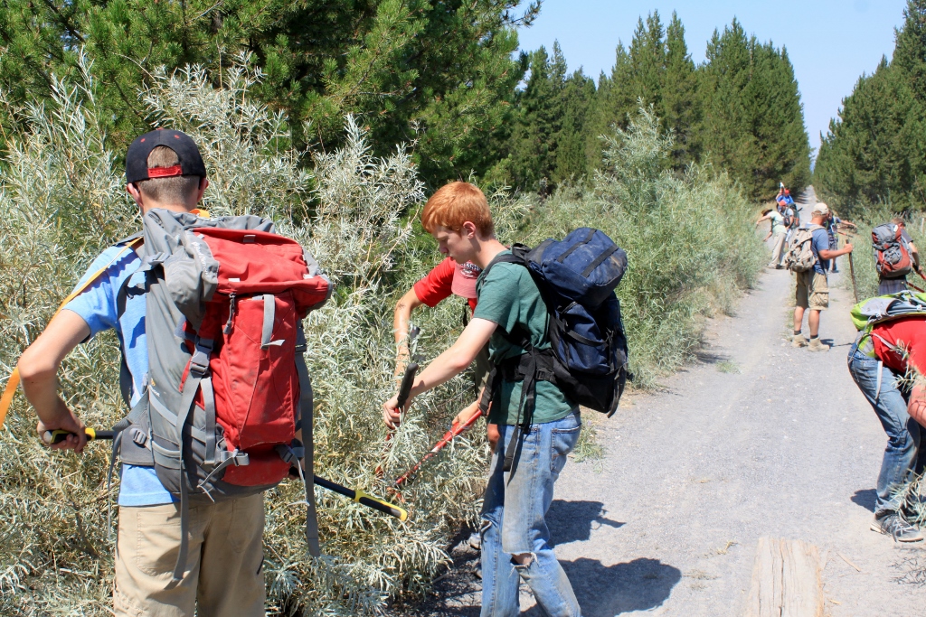
Along the way, each boy was issued a pair of loppers and we groomed the trail as we hiked it.  From time to time, the Right of Way would cross rivers and streams and we'd stop at them and take a dip.  Being August, it was pretty hot, so cool water was welcome.  The problem was that the water wasn't cool, it was downright cold and kind of shocking to the system.  One of the leaders is a policeman for his day job and may have had some military training.  He convinced some of the boys to do twenty burpees in the cold water.  My youngest son and one of the others did a bunch.  Only one boy got to twenty.  The prize for twenty was a pizza when we returned to civilization.  A burpee is what we used to call a squat thrust in gym class.  Starting from a standing position, you squat down to a crouch, with your hands on the ground you shoot your legs out straight, do a push-up, return to the crouch and then jump up as high as you can.  Repeat.

The coolest thing about the river crossings, though were the old railroad trestle bridges that we crossed.  There was evidence that they had been built and rebuilt over the years, and every now and then we'd find a Geo-cache.  That was kind of fun.  We added our expedition to the log and returned them to their rightful location.

Island Park Reservoir inlet or outlet, not sure which

This was a potty stop, one of the boys went off in the trees on the left side of the road, and when he came back I told him that was the girls bathroom!  That became a standing joke the rest of the week.  He was a good sport so no teenagers were harmed.

Uber cold water right there.

Cooling down

Burpee time

pain

There was a primal scream here

Shock to the system

Agony

Triumph

My youngest son facing the burpee challenge

Aaaaaaaaaaahhhhhhhhhhhh!

Trestle bridge

Geo-Cache

This is where the Geo-Cache was

Groomen das trailen, unt yah (didn't know I spoke German did you?)

Minnows

Signing in on the second Geo-Cache

Remnants of old pilings from the original trestle bridge

On the bridge above the old pilings

More trail grooming

The last several miles of the trail on this day were kind of brutal.  We had moved from the railbed onto the frontage road on our way to Island Park Boy Scout Camp.  It was hot, it was dusty, everybody was about out of water and there was almost no shade.  From time to time we'd pass a telephone pole and ten boys and leaders would line up in the shade for a few minutes just to cool off.  We finally arrived and set up camp.  After that it was time to play in the lake.  As I said before, camp season was over and we had the place all to ourselves.  We were good stewards though.  Didn't cause a lot of mischief.  Probably because we were too tired to get into much trouble.

The brutal slog on the frontage road

At last

On the lake at night

In the lake at night

The whistlin' and whittlin' brigade

It has become obvious to me at this point of the blogging that this is really a two part blog post.  I will return and blog about the final two days of this adventure.  Sunburns awaiting.


Thursday, April 13, 2017

April 2017: Southeastern Utah--Canyonlands and Arches National Parks--Part One


Sample landscape of Southern Utah
I took a hiatus from blogging for about a year and a half.  I have a little catch up to do.

The Hot Chick and I celebrated our anniversary a little early this year because I'll be in rehearsal for a play this time.  She had time off work at the same time I had spring break.  The planets aligned for a getaway to Utah.  For the last few years I have become more and more interested in Utah's five national parks and eight National Monuments.  I've purchased the all parks pass for the past two years with the intent to visit the Utah parks.  Last year, things didn't work out so we stuck with Yellowstone and Grand Teton National Parks.  I decided this year we would make it a priority to visit a couple of the Utah parks.  I'm glad I did.

Originally I intended to camp for at least two of the nights, but after the Hot Chick checked out the weather report she decided that 32 degrees at night was too cold for that, so I booked three nights at the Canyonlands Motor Inn in Monticello, Utah.  It was an old motel, probably constructed in the 1960's.  If you need to stay in a swanky place, this is not it.  We weren't planning to spend much time in the room, so that didn't matter.  The beds were new and actually pretty comfortable.  I don't often sleep well in a hotel or motel, but this was an exception.  I have no complaints about this motel, and would consider staying there again.  The beds were comfortable and the price was right.

We didn't have an itinerary for this trip other than we knew we wanted to spend one day at Arches National Park and one day at Canyonlands National Park.  We knew nothing about either park before we went.  I had originally intended to do Arches the first day and Canyonlands the second.  Literally, while we were in the car on our way to Arches, we changed our minds and headed to the southern entrance of Canyonlands to the region named "The Needles."  This first post will deal mainly with the archaeology of Canyonlands National Park.  The geology will follow.

Stop #1:  Newspaper Rock

On the highway between Monticello and Moab is a landmark called "Church Rock."  It is near the southern entrance to Canyonlands National Park.  Like everything else in this part of Utah, Church Rock is a remnant of a greater formation.  Everything else around the rock has been eroded away by rivers, rain, snow and wind.

Church Rock:  Note the layers of red, orange and white sandstone.  More on this later
I was a little reluctant to visit the Needles at first because I knew the entrance to Canyonlands was more than forty miles off the main highway.  I was concerned that it would be forty miles of uninteresting road.  I was wrong.  I commented to the Hot Chick several times that Canyonlands must be pretty spectacular if the road getting to it was so cool.  It was an incredibly scenic drive.  I found myself wondering why it wasn't included in Canyonlands National Park.

About twelve miles in on this road is an archaeological site called Newspaper Rock.  It's a collection of about 650 petroglyphs chiseled into a flat rock face.  The rocks in this part of Utah have a feature called Desert Varnish.  Iron and Manganese are dissolved by rainwater and redeposited on cliff faces. Any disturbance to the desert varnish exposes the lighter sandstone underneath, creating an ideal surface for creating petroglyphs.

These particular glyphs were created around 2000 by the Anasazi, Navajo, Ancestral Puebloan, Fremont and other tribes.  No one really knows what the glyphs mean.  Some speculate that it is a map showing traditional migration routes for people and game.  Others suggest it's a record of daily life in this area.  Some think it has religious or spiritual significance while others believe it's nothing more than ancient graffiti.  Whatever the case is, I thought it was really cool.  After we got back into the car, I mentioned to the Hot Chick that it didn't matter how good or bad Arches or Canyonlands were, this trip had already been worth it.  Newspaper Rock is a total highlight.

Interpretive materials

Protected overhang of Newspaper rock.
Now there is an iron railing to protect it from vandalism.

Overall scope of Newspaper Rock.  This is a major glyph site

Details.  Some of the feet have four toes, some have five and others have six.  Mutants or aliens perhaps?

Anytime I see a bison in a glyph site I have to photograph it.

Another bison

Petrified worm burrows in a paving stone at Newspaper Rock.

Stop #2:  The Road to Canyonlands

I said this before, but I'll say it again because sometimes I repeat myself sometimes.  The road to Canyonlands was so scenic, I wondered just how cool Canyonlands must be, and I also wondered why this section wasn't included in Canyonlands National Park.

What we had to deal with to get to Canyonlands

Disgusting

Will this never stop?

Are we there yet?

Why do I have to look at all this fantastic scenery?

Enough already!

Stop teasing me.  I want to go to Canyonlands!

Seriously?

It doesn't have to be this cool!
Stop #3:  Archaeology of Canyonlands National Park 


The obligatory shot in front of  the National Park sign.  Tourists, bah.

We finally made it to Canyonlands National Park after enduring all that spectacular scenery.  We first went to the visitors center and purchased the obligatory fridge magnets and hiking staff medallions.  One of the rangers at the visitors center was kind enough to go over the map with us and tell us what not to miss.  She said one of the things I most wanted to see was closed at this time of year due to quicksand.  Quicksand?  I'd love to see quicksand.  I've seen enough movies, I've read enough true life stories, I think I could get myself out of quicksand if I encountered it.  The site I didn't get to see was the Tower Ruin which is an Anasazi site.  Next time I come here I'll see this.

Neither the Hot Chick nor I were in top hiking shape this early in the year.  Since this was the first time either of us had been to Canyonlands, we agreed to see the basic tourist stuff and take short hikes.  I think it's okay to see the stuff from the road the first time you visit a national park.  But after one or two times, it's time to enter the backcountry and really experience what that park is all about.  It's kind of like the old days when you'd buy a rock album on vinyl and first you'd listen to the hits, but after awhile you get deeper and deeper into the album and realize that the best stuff is hidden.  The real essence of the band is in the deeper cuts.  National parks are like that too, I think.

We stopped at a short hike called Roadside Ruin which is an ancient granary made by Ancestral Puebloans about 2000 years ago.  Apparently there are old granaries and other ruins all over Canyonlands National Park.  At a future date, I want to visit Canyonlands and only go to the archaeological sites.  It was a short, easy hike about a third of a mile round trip.  As I was to find out about both of the national parks we visited, cairns mark the trails.  Cairns were everywhere.  Sometimes as trail markers other times as monuments to some long gone hiker.

The granary was a masonry structure of rocks and mud.  It was tucked under an overhang to keep the wind and rain out.  I'm sure that when it was in use there was a top on it to keep the vermin out.  This was a hidden spot, tucked in a small canyon and surrounded by thousand year old cedar and juniper trees.  You would have to know where to look if you were going to stash your grain here.

The interpretive materials in this park were excellent

This is the other side of the road from the trailhead.  I imagine the farmer who made the granary needed to use this as a landmark, same as we would.

The hidden granary

As you can see, it's tucked inside a large overhang

Hidden from view

A pothole.  More on these when we talk about geology

Cairns
The next spot on this part of the journey was a place called Cowboy Camp and Cave Spring.  The trail leads for a short distance under a sheltering overhang that was used first by Native Americans and then by cowboys.  After the archaeology, the trail continues up two ladders and onto the large rocks that appear to be frozen sand dunes.  Once again, cairns led the way.

Rock formations on the way to Cave Spring trail

More rock formations

For some reason they call these mushrooms

Same with these

Trail marker

At the trailhead

First stop at the cowboy camp

All the official photos of the cowboy camp look staged, but when we got there, everything looked as if the cowboys left with the intention of coming back but never did.

More cowboy stuff

The trail continued under the overhang.  It was pretty hot out in the sun but pleasantly cool under the rock.  Maybe the ancient ones knew what they were doing...

Home of an ant-lion.  A bug lives under the dirt at the bottom of the cone and waits for an ant to disturb the sides, then it pounces.

Ancient packrat nest.

More underhang

Another part of the cowboy camp

Don't trip and fall here.  It would be bad.

Cool stuff like this was everywhere

Then we came to the pictographs.

More red ocher pictographs 

This guy is probably important

more of the same

First time I've seen handprints in situ 

About the same size as my hand.  Looks like it was placed yesterday (but it wasn't)

This is the watersource for the natives and the cowboys.  Notice the soot on the overhang ceiling.  This was obviously a long term camp

Another shot of the water

Stuff like this was everywhere

The Hot Chick for scale

First ladder

Another cave

Then there was this marker.  Ever wonder how the Mormons settled the west so fast?  Look no further.  The real name of Mormon Tea is Ephedra viridis.  My ancestors were hopped up on natural speed!

What Mormon Tea looks like, (so you can avoid it...)

Second ladder

Then there was this guy.  He appeared to be swimming in the dirt.  He was weird.  Fit right in with me.

Scenery from on top of the rock

Strange formations within the sandstone

Here we were in the desert and there are these snow covered peaks in the background

A deep pothole which is a watersource for animals after the snow melts and after each rain.  More on these in the next post.

More of the incredible scenery from on top of the rock

Not getting tired of this scenery yet

More coolness

Things like this were everywhere

Check it out, another cairn

If one cairn is good, then six are obviously better

The overhangs from above

Another cool rock formation

One day this will fall.  Hopefully we won't be under it.

This was also cool

You see stuff like this at Zion National Park

Back to the overhangs

The texture here is cool.  I wonder if this is a product of flash flooding?

At some places here, my head touched the rock.  I'm 5'8"

Mushrooms on the way out.
We spent the entire day in Canyonlands, and what we saw is too big for a single blog post.  In a day or two I'll post the second leg of the Canyonlands trip.

As I explored Canyonlands I had the thought, "Wow, Yellowstone isn't the only national park."  I want to come back to Canyonlands and explore deeper into the backcountry.  One of the things I liked the most about Canyonlands is the fact that we had solitude.  The Needles area is fairly remote and much of the road area we drove on was dirt.  Unlike Arches, we practically had Canyonlands to ourselves.  That was intoxicating.