 |
| Sign at the beginning of the Fort Henry Historic Byway |
Why Did We Take This Trip?
So, here's the deal, we live in Southeast Idaho, about an hour and a half away from Yellowstone National Park to the North and an hour and a half away from Grand Teton National Park to the East. We 'Day Trip' to Yellowstone frequently. We know people who have lived here all of their lives and have only been to Yellowstone three or four times. That is probably a sin and they will have to answer to their god on judgement day. So I overstated.
There is one way to get to Yellowstone from my hometown, and that is Highway 20. State Highway 20, as I understand it begins in Idaho Falls, Idaho and runs all the way to the Montana Border.
FACT CHECK: Ok, so I did a fact check on Highway 20 because I made a statement that made me sound like I know what I'm talking about. Turns out I was wrong. Highway 20 is actually US-20 and is the longest road in the United States. Turns out I was epically wrong. US-20 begins in Newport, Oregon and terminates in Boston, Massachusetts. The route travels 3365 miles. Epic. Wrong. Why didn't I just go back and edit my original thought? Now people will know I'm fallible. Dangit!
So, anyway, US-20 is how you get to Yellowstone from here. There are a few dinger trips that connect to US-20 that we have taken from time to time. What I refer to as a dinger is a side trip. Kind of like a rabbit hole that once you go down it is sometimes more interesting than the original topic. One of those is the Mesa Falls Scenic Byway, another is the Earthquake Area in Montana and Idaho, but the one we took on this fine day was the Fort Henry Historic Byway.
Our destination was always going to be Yellowstone, and we finally made it, but the real rockstar of the trip was the Fort Henry Historic Byway.
Fort Henry
The Byway begins in Rexburg, Idaho on what becomes The Red Rock Road. This roadtrip begins at the North Rexburg Exit. When you get to the exit, when you see Walmart, go the other way. Go north on that road and it will take you down into the river bottoms of the Henry's Fork of the Snake River. About two thirds of the way across the river bottoms there are some markers that designate where Fort Henry stood. There is a modern marker and an older one. Apparently, in 1937, the Boy Scouts of America discovered the original site of Fort Henry and made a marker. The two markers give very different locations for the fort, and Henry wasn't there long enough for alot of intense archaeological stuff to exist. He was there for about one winter and called it quits. More about Henry later.
 |
| Official State marker |
 |
| Boy Scout marker |
 |
| Plaque |
 |
| So, somewhere out here was a fort |
 |
| Or maybe it was here. |
About this Henry guy. There was a Fort Henry in Montana. There was a Fort Henry in Idaho. There is the Henry's Fork of the Snake River. There is a Henry's Lake in Idaho. After the war of 1812, Andrew Henry mountain manned back into the area and built a fort at the headwaters of the Yellowstone river. And he called it, wait for it, Fort Henry. This guy really liked himself it seems.
Andrew Henry was a mountain man who explored this area in the very early 1800's. He was the co-founder of a fur and trading company called, wait for it..... The Rocky Mountain Fur Company, otherwise known as Ashley's Hundred. He went into business with William H. Ashley. They employed a hundred fur trappers and traders. I don't know anything about these guys, but I imagine Henry thought it should be named Henry's Hundred. Makes sense, flows off the tongue better. In the end, probably because it irked him that Ashley got the nickname for the company, he attached his name to every geographic feature he could.
In 1810, he founded a trading post near what is present day Saint Anthony, Idaho and named it after himself. It was called Fort Henry. It wasn't really a fort in the traditional sense because it wasn't garrisoned by the army or cavalry. They were busy on the other side of the Mississippi getting ready to fight the British. It was really more of a trading post. They only got 40 bales of fur that winter, and it was a very hard winter and they learned what horse tasted like. After that harsh winter, and Idaho is known for harsh winters, they abandoned the fort and made their living somewhere else.
To put this into historical context, in the same year that Andrew Henry was establishing Fort Henry in Idaho, Beethoven wrote this piece called
Für Elise (For Elise). I think if Andrew Henry had heard this music, he might have renamed it For Andrew Henry.
One of the mountain men employed by Henry and Ashley was a guy named Hugh Glass. On one of their expeditions, Hugh Glass was mauled by a grizzly bear so badly that everyone believed he would die. This is how tough people were back then, as the bear was mauling him, Hugh Glass fought back and killed the bear with a knife. They carried him on a litter for two days, but the terrain was tough and winter was coming. Hugh Glass was their friend, so Andrew Henry, who had to get everyone else to safety, left two guys with Glass to make sure he was comfortable when he died and to bury his remains. Then, when Glass was buried, they were to meet up with the rest of the company at a specified location. When Glass didn't die right away, the two mountain men (one of whom may have been Jim Bridger) took his weapons and supplies and took off. They left him to die. The only thing he had left besides his clothes was the hide of the bear that he had killed.
Hugh Glass crawled 200 miles to safety, then he went on the warpath for the two guys that had abandoned him. There have been two movies made of this and several other depictions in popular media.
Man in the Wilderness and
The Revenant. Leonardo DiCaprio finally got his gold statuette for his role as Hugh Glass in
The Revenant. These guys lived here, where I live. If they can survive all that stuff, I can survive sheltering in place for a few weeks. Tough hombres.
Sugar Beet Slicer
Idaho, especially southeast Idaho is known for it's Russet potatoes. World famous. You can't go to a Five Guys Burgers without seeing that the potatoes grown for their fries came from local growers here. They put it up on the wall every time they open a new bag. I know some of the growers who sell to Five Guys. Every French fry from McDonald's from anywhere in the world comes from Idaho.
So who would have thought that southeast Idaho was once almost as famous for sugar beets as we are for potatoes? There is a sugar company called C & H which stands for California and Hawaii. They produce cane sugar. There used to be a sugar company called U & I for Utah and Idaho. Sugar beets were a huge cash crop in southeast Idaho from the early 1900's until about 1979 when production ceased. I remember people I knew made their high school living hoeing beets. There is a town near where I live called Sugar City. It was built for the purpose of growing and harvesting sugar beets. Now, there is no sugar in Sugar City, but along the Fort Henry Historic Byway there is a ruin from the era when sugar was king in southeast Idaho.
The ruin is on private property, but the owner has made it into a kind of shrine and allows people to freely visit. It was interesting, and actually way more interesting than I thought it would be.
 |
| Sign for the Sugar Beet Slicer |
 |
| Random farm machinery from the period |
 |
| Outbuilding |
 |
| The ruin |
 |
| interior |
 |
| So there is a ruined castle in southeast Idaho. Who knew? |
 |
| From a different angle |
 |
| Obviously the interpretive materials are homemade. Interesting still |
 |
| A combine of sorts |
 |
| Full round |
Sand Dunes
The Red Rock Road as it is commonly called passes through the Saint Anthony Sand Dunes. The road is called the Red Rock Road because in the old days, when it was a dirt road, it was routinely covered with red scoria gravel that had been pulverized from one of sixteen cinder cones found in the steppe in that area. Today, the red rock is quarried and pulverized and used on roads during the winter in southeast Idaho instead of salt. It's dirty and messy but not as hard on your car as salt is.
Another fun fact about the cinder cones is that within the red rock, there are feldspar crystals that are slightly yellow and can be cut into gemstones. They are really very pretty. I have mined them, cleaned them and sent them to my cutter in Bangkok, Thailand and they have come back very beautiful. Sadly, there isn't much of a market for light yellow feldspar. In some places it is called Sunstone.
Who knew that world class sand dunes would be located in southeast Idaho? People who ride ATV's swear by these dunes. I read a review several years ago in an ATV journal that the dunes in Saint Anthony, Idaho are the best in the nation for off roading. As I recall from the journal, there are about ten different types of sand features that people like to ride on. The only place in North America where all ten features are present is in Saint Anthony, Idaho. Most of the ten features here are world class. The wind blows all the time in Idaho, that's why we have sand dunes.
 |
| Note the cinder cone in the background. At least sixteen of these out on the desert |
 |
| This is not even the coolest part of the dunes |
Civil Defense Caves
I grew up in the 1960's. I remember every Saturday at noon, the city would test the air raid siren in case of an incoming nuclear missile strike. I remember thinking, if Russia wanted to attack us, they should launch the attack at noon on Saturdays. Southeast Idaho was a first strike target because of the Nuclear Reservation in Arco, Idaho.
Our entire plan for survival of a nuclear strike was for everybody to head out into the desert near Saint Anthony, Idaho along the Red Rock Road and shelter in a cave that the Civil Defense people had stocked with food and water. There was room and supplies in the caves for about 5000 people. That's it, our entire plan for surviving a nuclear war was for 5000 people to become cavemen. Everybody else you knew would be dead or become nuclear zombies. There was no privacy in the caves, so it was likely that the 5000 people would stay at 5000 people. Population probably wouldn't grow significantly in that time.
Now, the Civil Defense Caves are an area of interest for people on day trips, spelunkers and graffiti artists. It is one of the sites along the Fort Henry Historic Byway so we stopped. We have stopped here before.
 |
| Shooters vandalized the sign |
 |
| concrete interpretive materials, graffiti artists vandalized it |
 |
| What the sign says. Birds also vandalize this |
 |
| How it was going to be used |
 |
| Cave etiquette. |
 |
| Pahoehoe |
 |
| Entrance to the cave. Vandals have been here too |
 |
| The Hot Chick about to descend into the Cave of Caerbannog. You have to admit, it does look like that |
 |
| Inside the cave with 5000 of our very best friends |
 |
| Looking back |
 |
| The Hot Chick |
 |
| The Hot Chick |
 |
| Climbing out of the cave |
 |
| The last few miles to the Civil Defense Caves are along a dirt track |
 |
| Even nuclear war couldn't destroy these bad boys |
 |
| Remember me talking about the Red Rock Road? They still do it in places |
 |
Vandals. You know, the word Vandalism is probably a racist term. The Vandals were a Roman era ethnic German group
that sacked Rome. Since Rome was the enlightened capital of the world, it was unthinkable that someone like the Vandals
could sack it. But they did. And forever after they have to deal with their ethnicity being synonymous with destruction and
ruination. I don't think there is a tribe anywhere now that identifies as Vandals though. The same could be said of the term, "He Gypped me!" That is a racist term describing the stereotype for the Romani people, also known as the Gypsies. |
Sagebrush Steppe
When we think of the steppes, we tend to think of the Mongols riding their ponies over the steppes of central Asia. Growing up in southeast Idaho, I was always told we lived in a desert. Instead, this area is steppe land, just like central Asia. During the Cold War, three world famous Russian Impressionists defected from the Soviet Union and relocated to southeast Idaho. Turns out, southeast Idaho looked alot like the steppes of Ukraine and Russia. I was living in West Yellowstone in the summer of 1988 during the worst fire season in Yellowstone in recorded history. We were heartsick. I never believed Yellowstone could recover in my lifetime. At the end of that summer, we moved away to Minnesota and then Buffalo, New York. We were there for about six years and came back to southeast Idaho for a year. I don't think we went to Yellowstone once during that year. Then we moved up to the greater Seattle area for another six years. When we returned in 2000, we headed up to Yellowstone and were absolutely amazed. The fires were actually a good thing. Destructive, to be sure, but a good thing. The ancient forest, choked with dead wood and debris had burned. Lodgepole Pines have a serotinous cone that requires heat of a certain temperature to release the seeds. That temperature actually coincides with the temperature generated by a forest fire. Again, who knew? There were almost no young trees in Yellowstone for a very long time because the National Park Service had put out every fire, immediately for seventy years. Protecting the forest was actually killing it. Nature has a way of self correcting.
Anyway, when we went back to Yellowstone in 2000 we were stunned. The park was new, fresh, alive, dynamic! Species missing from the park had returned. Some came of their own free will and others were reintroduced. The park was green with new growth pine. The transformation was incredible.
I told you that so I could tell you this. Sagebrush doesn't react the same way to fire that Lodgepole Pine does. When sagebrush burns, it can take a hundred years to come back. Sagebrush is an important food source to many species including deer and elk. It provides shelter and protection for the animal smallfolk like rabbits and marmots.
Before the westward expansion of our country, the great plains were steppeland. Vast steppes as far as the eye could see and the buffalo roamed. (I usually call them by their proper name, bison, but I was making a song reference.) The westward expansion took care of all that steppeland and now, the largest steppe in the United States is on the Snake River Plain in southern Idaho, and it is endangered.
A few summers ago, a lighting strike out in the steppes caught the sagebrush on fire and burned about 10,000 acres. We aren't getting that back in our lifetimes. So when a fire burns in a pine forest, it can be a thing of beauty, but when it burns in the steppes, it is a tragedy. Now, I am not saying every forest fire is a good thing. What happened in California last year was a tragedy and was devastating to many people. My heart goes out to them. I know some of them who lost their homes in those fires.
 |
| Sagebrush Steppe |
 |
| Tragic loss of food and habitat. We'll never see the sagebrush return here. My great grandchildren might |
 |
| More steppeland. Underneath the sagebrush are successive lava flows. One after another from the great rift in Idaho's steppeland. Erosion of the lava breaks down particles and the loess (soil type) gets deposited out in the valley and the sand collects near Saint Anthony at the dunes. Potatoes and sugar beets grow in loess, ATV;s grow in sand. You can see out in the distance collapsed lava tubes. These are the same features that created the Civil Defense Caves. Partially collapsed lava tubes. |
 |
| The burn on the west side of the road. Thankfully, the road created a firebreak and stopped the destruction from being worse. |
 |
| More fire destruction |
 |
| One more, pointed north |
Camas Meadows Battlefield
Because of the sensitive nature of this historic battlefield, I am not going to give exact directions to it. The battlefield has survived for 143 years with little or no vandalism. If you want to see the battle site, you can do a little research for yourselves and find it. That is if you are people who are into low impact hiking. If you are a hooligan or a vandal, or a delinquent, I will give you the exact address to the battlefield
here.
I had heard about this battlefield before, but when I finally visited it, I felt a reverence for the men who fought and died here, but more importantly the men who fought and lived here. I'll explain that in a bit.
In 1877, Chief Joseph of the Nez Perce tribe left their reservation in Oregon with his band. Because of broken treaties and stupid things some teenagers had done, it became apparent that they would have to leave. Joseph and the Nez Perce just wanted to live in peace but also live according to their own terms and the agreements they had with the United States Government. They fled the reservation and fought a skirmishing retreat with the United States Cavalry over four states. They wanted to cross the border into Canada to join with Sitting Bull who self exiled there to avoid capture for the Battle of the Little Bighorn.
Chief Joseph was the best known of the Nez Perce and he has been given credit for the strategy of the war. Joseph was not a war chief, but rather took care of the people while the war chiefs fought. That being said, he was most likely responsible for the strategy of a skirmishing retreat. There were a few times in the 1100 mile trek across Oregon, Idaho, Wyoming and Montana that the Nez Perce could have wiped out the cavalry to a man, similar to what had happened to Custer's command in the Battle of the Little Bighorn, but they didn't. They simply wished to leave. Joseph was probably the one responsible for that stratagem. A war chief would have seen their advantage and taken it. Joseph never forgot the mission, so they would engage the cavalry in a battle as the camp fled. When the women, children, old and sick people were out of harm's way, the warriors broke off the attack and joined their people as a rearguard to protect them during their flight.
Remember Andrew Henry? When the Nez Perce and the pursuing Cavalry, under the command of General Oliver Otis Howard were passing by the lake he had named for himself, they camped near the lake. Howard was about fifteen miles west of Joseph's encampment. The Nez Perce decided they needed to slow the cavalry down and orchestrated a raid in the middle of the night to stampede the cavalry's mounts. The goal was to make the cavalry into infantry. Riding boots do not make good walking boots.
At 4:00 AM, about 28 warriors crept into where the livestock were and began releasing them. One of Howard's pickets noticed something and cried out, "Who goes there?" At the same moment, a gun accidentally discharged and chaos happened. You can plan a battle, you can plan a football game, you can plan just about anything, and it looks great on paper, but when everything begins and that one thing you didn't anticipate happening happens, all the plans go out the window.
The raiders succeeded in releasing 200 army mules, but few horses. They stampeded them toward their position fifteen miles east. Howard, at 4:00 in the morning ordered 150 men to pursue and recover the stock. Without the mules, Howard's mobility was compromised. He needed those mules. The men caught up with the Nez Perce in a place called Camas Meadows and began a fight. Three companies of cavalry had joined the fight. The Nez Perce had left a few men out in the open as decoys and the cavalry dug in on a small lava rock shelf. By the time the cavalry figured out that the men were decoys, it was too late. The actual band had crept up using the natural terrain of collapsed lava tubes and rocky outcroppings to get closer to the cavalry.
Two of the companies retreated back to Howard and the third one dug in. The rock shelf they were defending left little in the way of cover. It was basically indefensible. The lava bedrock was just inches under the loess (soil) so digging foxholes was out of the question. The remaining company of soldiers threw up breastworks of lava rock and hid behind them. The soldiers referred to this site as 'The Frying Pan.' The cavalry in 1877 was using the Springfield Model 1873, breech loading, single shot service rifle. Many of the Nez Perce warriors were using repeating rifles, much as the Lakota had in the Battle of the Little Bighorn. Howard's soldiers realized they were not only outnumbered, they were outgunned, outflanked, outclassed and almost out of food, water and ammunition. The battle lasted about six hours, give or take and as suddenly as it had begun, it was over. The Nez Perce warriors melted away to protect the rear of the column of the nomadic village.
Howard's mobility was compromised and the Nez Perce put a great deal of distance between themselves and the cavalry. They put enough distance between them that the women of the village asked Joseph if they couldn't go see the sights in Yellowstone, which had been designated a National Park just five years earlier. They had heard about all the great wonders there. So a day or so after a battle, the Nez Perce became tourists. Yellowstone has that effect on people.
We visited the battlefield. There is a kiosk with some interpretive materials describing the Nez Perce war and the trek across four states and of course the Battle of Camas Meadows. There are some iron sculptures of Nez Perce warriors on horseback there. As I said at the beginning of this section, I will not tell how to get exactly to the battlefield. If you wish to find it, a little research will go a long way. It has been suggested by some people online that in order to protect this site from vandals that we shouldn't give too good of details on how to find it. So that is why. I will tell you that if you are a low impact enjoyer of nature and history, it is well worth it. If you are a vandal, it's really boring and not worth the time or effort of finding it.
I spent quite a bit of time at The Frying Pan, looking out over the battlefield and crouching down in the rifle pits (the breastworks the cavalry soldiers hastily erected that still stand 143 years later) and trying to get a feel for what happened here all those years ago. My romantic self could hear hoofbeats, rifle shots, men shouting orders, horses objecting. I felt a reverence there the same as I have with other battlefields I have visited. All in all, there are about 30 rifle pits still in existence. I got the feeling that some of them had been reconstructed over the years. They were too clean and there were no weeds growing up in them. Some others seemed to be for real. Then there were some others that had sagebrush growing up through them. Those rifle pits were absolutely authentic. I don't know, maybe all of them were authentic or maybe some of them had been rebuilt on the original sites.
The Nez Perce had every possible advantage over that one company of cavalry for hours. They fired hundreds of rifle rounds at the soldiers. The soldiers fired back. Six hours of fighting and the results were that the cavalry had one man dead, two mortally wounded and 8 or 9 mildly wounded. The Nez Perce warriors claimed two men had minor wounds. What I said earlier about having reverence for the men who died but also for the men who lived, this is what I was talking about. The Nez Perce could have destroyed that company of soldiers to a man but didn't. Every man in that company who lived another day owed it to chiefs like Joseph who never forgot the mission.
 |
| Kiosk with interpretive materials |
 |
| sculptures of Nez Perce Warriors. These sculptures have been placed all along the Nez Perce Trail, which belongs to the historic byways club. |
 |
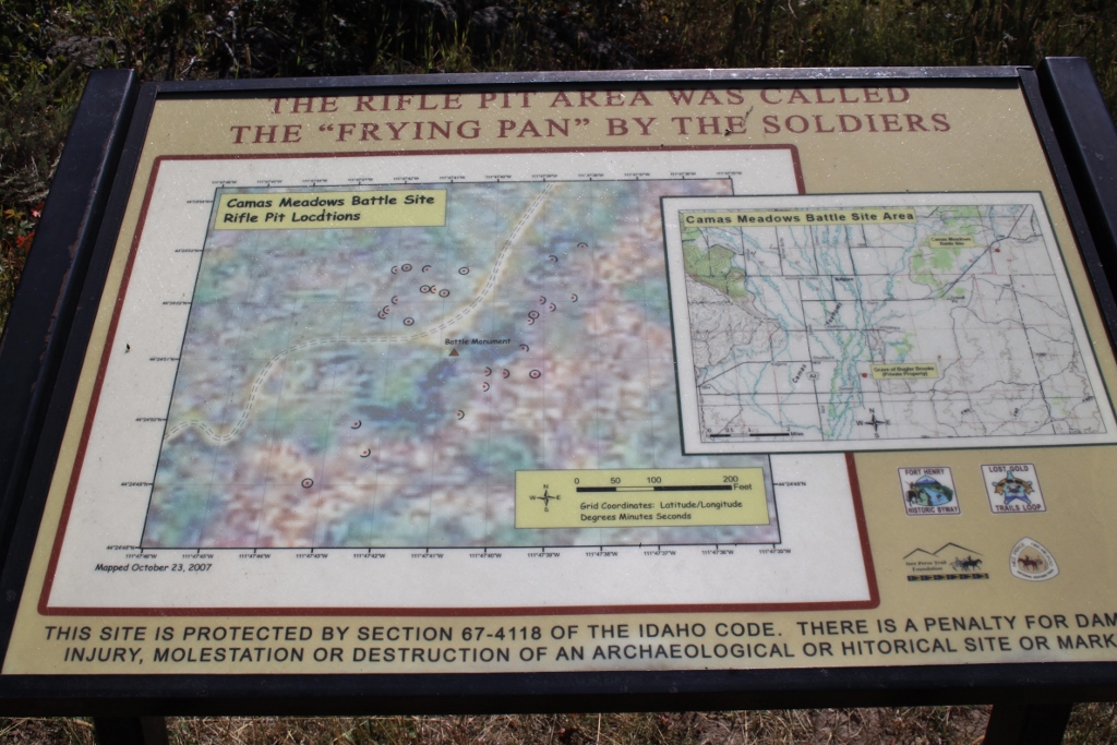
| Diagram of the rifle pits that still exist to this day. Also a warning about disturbing archaeological sites |
 |
| If I were to put money down, I'd say this is a reconstructed pit |
 |
| because I'm comparing it to this |
 |
| and this |
 |
| This one also may be a reconstructed pit |
 |
| The view from inside a rifle pit, at gun level. That is what the soldiers could see |
 |
| This one appears to be authentic |
 |
| View from inside |
 |
| These breastworks are everywhere on The Frying Pan |
 |
| This one has enough plant growth in it that I believe it is authentic |
 |
| This one as well. The desert patina on the rocks in the breastwork resembles the patina on the exposed bedrock in the foreground |
 |
| I'm halvsies on this one |
 |
| Full round. Probably authentic, not rebuilt |
 |
| There is a dropoff right between the two rocky outcrops. The soldiers were where I am with the camera and the Nez Perce were creeping up in the dropoff completely out of sight |
 |
| Collapsed lava tube |
 |
| When you look at a distance, the terrain looks completely flat, but when you look closer, there is all kinds of this stuff everywhere. Places where warriors or cavalrymen could creep along, out of sight of the enemy |
 |
| There is the dropoff |
 |
| From another direction, this is what the soldiers could see |
 |
| Another rifle pit. These things in The Frying Pan were at most 12" tall |
 |
| And another one |
 |
| View from the pit |
 |
| This one I believe to be authentic |
 |
| I hope they are all authentic. I do believe that if any were reconstructed, they were reconstructed on the original site |
 |
| The plant growth here is evidence that this one is legit. Remember, it takes about a hundred years for sagebrush to establish. The battle was 143 years ago |
 |
| Here's another one |
 |
| This is the area where the soldiers picketed their horses during the battle. It is right in the middle of all the rifle pits, and it is lower than The Frying Pan so the horses would have been sheltered from rifle fire |
 |
| Monument at the site of the rifle pits |
 |
| and the plaque commemorating it. |
Yellowstone as an Afterthought
We did make it all the way in to Old Faithful on this trip. After all, that is where we had been heading in the first place. I have to tell you, though that after all we had done that day, as cool as Yellowstone is, we had already had a full day. We got into the park, and I took a few pictures of some animals, including some really great pictures of a Great Blue Heron. We got to Old Faithful just in time to see it go off in the distance behind some trees. That is okay because we have seen it ten hundred million billion times. We stopped in to the lodge and The Hot Chick got some ice cream and I got some mango sorbet. I dunno, that stuff just tastes better in Yellowstone. Then we went home. It was an incredible day. I wouldn't want to do it every time we go to Yellowstone, but I'd like to do it again sometime.
 |
| Great blue heron |
 |
| Again |
 |
| Posing |
 |
| Missed it by that much |
 |
| But we did see that Castle was about to erupt so we caught that one |
 |
| I don't take many bison shots |
 |
| or elk |
 |
| dusk in Yellowstone |
 |
| The heron was still there, or at least a silhouette of one |
 |
| They are magnificent |
 |
| Reflections |
 |
| This is what I have to put up with, living in this part of the world |
This is an amazing part of the world I live in. Beautiful scenery, interesting history. People who live here and never leave often take it for granted. We left for twelve years and when we came back we had a renewed sense of wonder about this great land we live in.


No comments:
Post a Comment