 |
| Sample landscape of Southern Utah |
I took a hiatus from blogging for about a year and a half. I have a little catch up to do.
The Hot Chick and I celebrated our anniversary a little early this year because I'll be in rehearsal for a play this time. She had time off work at the same time I had spring break. The planets aligned for a getaway to Utah. For the last few years I have become more and more interested in Utah's five national parks and eight National Monuments. I've purchased the all parks pass for the past two years with the intent to visit the Utah parks. Last year, things didn't work out so we stuck with Yellowstone and Grand Teton National Parks. I decided this year we would make it a priority to visit a couple of the Utah parks. I'm glad I did.
Originally I intended to camp for at least two of the nights, but after the Hot Chick checked out the weather report she decided that 32 degrees at night was too cold for that, so I booked three nights at the Canyonlands Motor Inn in Monticello, Utah. It was an old motel, probably constructed in the 1960's. If you need to stay in a swanky place, this is not it. We weren't planning to spend much time in the room, so that didn't matter. The beds were new and actually pretty comfortable. I don't often sleep well in a hotel or motel, but this was an exception. I have no complaints about this motel, and would consider staying there again. The beds were comfortable and the price was right.
We didn't have an itinerary for this trip other than we knew we wanted to spend one day at Arches National Park and one day at Canyonlands National Park. We knew nothing about either park before we went. I had originally intended to do Arches the first day and Canyonlands the second. Literally, while we were in the car on our way to Arches, we changed our minds and headed to the southern entrance of Canyonlands to the region named "The Needles." This first post will deal mainly with the archaeology of Canyonlands National Park. The geology will follow.
Stop #1: Newspaper Rock
On the highway between Monticello and Moab is a landmark called "Church Rock." It is near the southern entrance to Canyonlands National Park. Like everything else in this part of Utah, Church Rock is a remnant of a greater formation. Everything else around the rock has been eroded away by rivers, rain, snow and wind.
 |
| Church Rock: Note the layers of red, orange and white sandstone. More on this later |
I was a little reluctant to visit the Needles at first because I knew the entrance to Canyonlands was more than forty miles off the main highway. I was concerned that it would be forty miles of uninteresting road. I was wrong. I commented to the Hot Chick several times that Canyonlands must be pretty spectacular if the road getting to it was so cool. It was an incredibly scenic drive. I found myself wondering why it wasn't included in Canyonlands National Park.
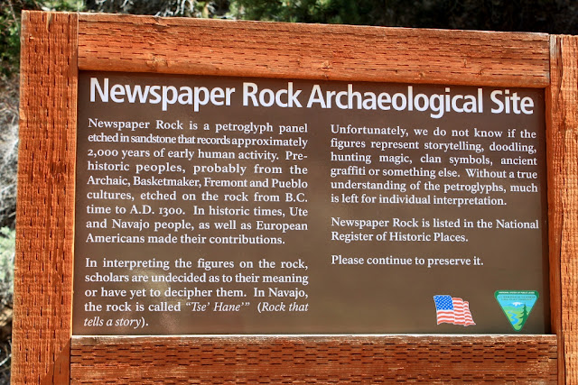
About twelve miles in on this road is an archaeological site called Newspaper Rock. It's a collection of about 650 petroglyphs chiseled into a flat rock face. The rocks in this part of Utah have a feature called Desert Varnish. Iron and Manganese are dissolved by rainwater and redeposited on cliff faces. Any disturbance to the desert varnish exposes the lighter sandstone underneath, creating an ideal surface for creating petroglyphs.
These particular glyphs were created around 2000 by the Anasazi, Navajo, Ancestral Puebloan, Fremont and other tribes. No one really knows what the glyphs mean. Some speculate that it is a map showing traditional migration routes for people and game. Others suggest it's a record of daily life in this area. Some think it has religious or spiritual significance while others believe it's nothing more than ancient graffiti. Whatever the case is, I thought it was really cool. After we got back into the car, I mentioned to the Hot Chick that it didn't matter how good or bad Arches or Canyonlands were, this trip had already been worth it. Newspaper Rock is a total highlight.
 |
| Interpretive materials |
 |
Protected overhang of Newspaper rock.
Now there is an iron railing to protect it from vandalism. |
 |
| Overall scope of Newspaper Rock. This is a major glyph site |
 |
| Details. Some of the feet have four toes, some have five and others have six. Mutants or aliens perhaps? |
 |
| Anytime I see a bison in a glyph site I have to photograph it. |
 |
| Another bison |
 |
| Petrified worm burrows in a paving stone at Newspaper Rock. |
Stop #2: The Road to Canyonlands
I said this before, but I'll say it again because sometimes I repeat myself sometimes. The road to Canyonlands was so scenic, I wondered just how cool Canyonlands must be, and I also wondered why this section wasn't included in Canyonlands National Park.
 |
| What we had to deal with to get to Canyonlands |
 |
| Disgusting |
 |
| Will this never stop? |
 |
| Are we there yet? |
 |
| Why do I have to look at all this fantastic scenery? |
 |
| Enough already! |
 |
| Stop teasing me. I want to go to Canyonlands! |
 |
| Seriously? |
 |
| It doesn't have to be this cool! |
Stop #3: Archaeology of Canyonlands National Park
 |
| The obligatory shot in front of the National Park sign. Tourists, bah. |
We finally made it to Canyonlands National Park after enduring all that spectacular scenery. We first went to the visitors center and purchased the obligatory fridge magnets and hiking staff medallions. One of the rangers at the visitors center was kind enough to go over the map with us and tell us what not to miss. She said one of the things I most wanted to see was closed at this time of year due to quicksand. Quicksand? I'd love to see quicksand. I've seen enough movies, I've read enough true life stories, I think I could get myself out of quicksand if I encountered it. The site I didn't get to see was the Tower Ruin which is an Anasazi site. Next time I come here I'll see this.
Neither the Hot Chick nor I were in top hiking shape this early in the year. Since this was the first time either of us had been to Canyonlands, we agreed to see the basic tourist stuff and take short hikes. I think it's okay to see the stuff from the road the first time you visit a national park. But after one or two times, it's time to enter the backcountry and really experience what that park is all about. It's kind of like the old days when you'd buy a rock album on vinyl and first you'd listen to the hits, but after awhile you get deeper and deeper into the album and realize that the best stuff is hidden. The real essence of the band is in the deeper cuts. National parks are like that too, I think.
We stopped at a short hike called Roadside Ruin which is an ancient granary made by Ancestral Puebloans about 2000 years ago. Apparently there are old granaries and other ruins all over Canyonlands National Park. At a future date, I want to visit Canyonlands and only go to the archaeological sites. It was a short, easy hike about a third of a mile round trip. As I was to find out about both of the national parks we visited, cairns mark the trails. Cairns were everywhere. Sometimes as trail markers other times as monuments to some long gone hiker.
The granary was a masonry structure of rocks and mud. It was tucked under an overhang to keep the wind and rain out. I'm sure that when it was in use there was a top on it to keep the vermin out. This was a hidden spot, tucked in a small canyon and surrounded by thousand year old cedar and juniper trees. You would have to know where to look if you were going to stash your grain here.
 |
| The interpretive materials in this park were excellent |
 |
| This is the other side of the road from the trailhead. I imagine the farmer who made the granary needed to use this as a landmark, same as we would. |
 |
| The hidden granary |
 |
| As you can see, it's tucked inside a large overhang |
 |
| Hidden from view |
 |
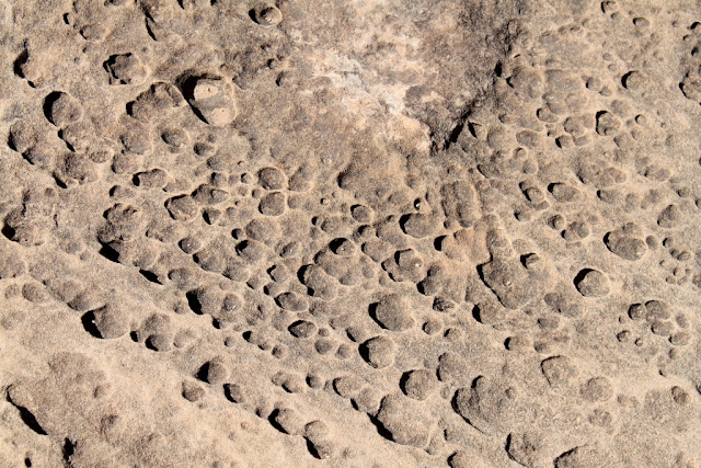
| A pothole. More on these when we talk about geology |
 |
| Cairns |
The next spot on this part of the journey was a place called Cowboy Camp and Cave Spring. The trail leads for a short distance under a sheltering overhang that was used first by Native Americans and then by cowboys. After the archaeology, the trail continues up two ladders and onto the large rocks that appear to be frozen sand dunes. Once again, cairns led the way.
 |
| Rock formations on the way to Cave Spring trail |
 |
| More rock formations |
 |
| For some reason they call these mushrooms |
 |
| Same with these |
 |
| Trail marker |
 |
| At the trailhead |
 |
| First stop at the cowboy camp |
 |
| All the official photos of the cowboy camp look staged, but when we got there, everything looked as if the cowboys left with the intention of coming back but never did. |
 |
| More cowboy stuff |
 |
| The trail continued under the overhang. It was pretty hot out in the sun but pleasantly cool under the rock. Maybe the ancient ones knew what they were doing... |
 |
| Home of an ant-lion. A bug lives under the dirt at the bottom of the cone and waits for an ant to disturb the sides, then it pounces. |
 |
| Ancient packrat nest. |
 |
| More underhang |
 |
| Another part of the cowboy camp |
 |
| Don't trip and fall here. It would be bad. |
 |
| Cool stuff like this was everywhere |
 |
| Then we came to the pictographs. |
 |
| More red ocher pictographs |
 |
| This guy is probably important |
 |
| more of the same |
 |
| First time I've seen handprints in situ |
 |
| About the same size as my hand. Looks like it was placed yesterday (but it wasn't) |
 |
| This is the watersource for the natives and the cowboys. Notice the soot on the overhang ceiling. This was obviously a long term camp |
 |
| Another shot of the water |
 |
| Stuff like this was everywhere |
 |
| The Hot Chick for scale |
 |
| First ladder |
 |
| Another cave |
 |
| Then there was this marker. Ever wonder how the Mormons settled the west so fast? Look no further. The real name of Mormon Tea is Ephedra viridis. My ancestors were hopped up on natural speed! |
 |
| What Mormon Tea looks like, (so you can avoid it...) |
 |
| Second ladder |
 |
| Then there was this guy. He appeared to be swimming in the dirt. He was weird. Fit right in with me. |
 |
| Scenery from on top of the rock |
 |
| Strange formations within the sandstone |
 |
| Here we were in the desert and there are these snow covered peaks in the background |
 |
| A deep pothole which is a watersource for animals after the snow melts and after each rain. More on these in the next post. |
 |
| More of the incredible scenery from on top of the rock |
 |
| Not getting tired of this scenery yet |
 |
| More coolness |
 |
| Things like this were everywhere |
 |
| Check it out, another cairn |
 |
| If one cairn is good, then six are obviously better |
 |
| The overhangs from above |
 |
| Another cool rock formation |
 |
| One day this will fall. Hopefully we won't be under it. |
 |
| This was also cool |
 |
| You see stuff like this at Zion National Park |
 |
| Back to the overhangs |
 |
| The texture here is cool. I wonder if this is a product of flash flooding? |
 |
| At some places here, my head touched the rock. I'm 5'8" |
 |
| Mushrooms on the way out. |
We spent the entire day in Canyonlands, and what we saw is too big for a single blog post. In a day or two I'll post the second leg of the Canyonlands trip.
As I explored Canyonlands I had the thought, "Wow, Yellowstone isn't the only national park." I want to come back to Canyonlands and explore deeper into the backcountry. One of the things I liked the most about Canyonlands is the fact that we had solitude. The Needles area is fairly remote and much of the road area we drove on was dirt. Unlike Arches, we practically had Canyonlands to ourselves. That was intoxicating.


No comments:
Post a Comment