.jpg) |
| Ten Mile River at the trailhead for Tusten Mountain Trail. Ten Mile River is a tributary to the Delaware River |
I had the opportunity to attend Cobalt Studios Summer Scenic Painting Seminar this year. I have wanted to attend Cobalt for 25 years and all the planets aligned and all the ducks got in a row to make it happen finally. I'll talk more about what I learned at Cobalt on a different blog. Suffice it to say I spent three glorious weeks in Upstate New York in the foothills of the Catskill Mountains.
We spent all day, every day, Monday through Friday painting and learning to paint. The weekends were ours to do with what we pleased. I had spoken with a National Park Service ranger about what to do in this area and she told me about six hikes along the Delaware River that were managed by the park service. If you hiked all of them you could get a patch. We had three weekends to get it, so some of the other students and I decided we were going after the patch.
Hike #1: Tusten Mountain
The Tusten Mountain Trail passes by the remains of the old town of Tusten where timber and quarrying was the industry. All that is left of Tusten are stone walls, foundations and roads.
The trail crosses an old stone bridge, built in 1875 at the trailhead. Since 1927 the Boy Scouts of America have owned this area and co-manage it with the National Park Service. The Tusten Mountain Trail and one other are the only scout trails open to the public on this scout reservation. The trail is clearly marked with yellow blazes on the trees.
The Tusten Mountain Trail is approximately a three mile loop trail with elevation gain of around 590 vertical feet. The top elevation of this hike is approximately 1230 feet above sea level. It is described in the literature as a moderately difficult hike. All things are relative I suppose.
After the stone bridge, the trail follows an old road for about half a mile. Along the road, old stonework is visible. A spur trail cuts off to the right and the trail continues about a hundred yards into the forest to the registration station. There was a neat little cairn at this point of the trail.
.jpg) |
| Bridge across the Ten Mile River |
.jpg) |
| Flat boulders in the Ten Mile river |
.jpg) |
| Sign at the trailhead |
.jpg) |
| Ruins of the old town of Tusten |
.jpg) |
| Nature reclaims everything eventually |
.jpg) |
| The old quarry road for the first half mile of the trail |
.jpg) |
| Cairn at the registration station |
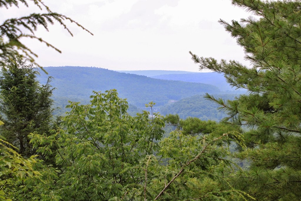
After the cairn, the trail becomes a true footpath and leaves the road. The trail is reasonably steep for this part of the country. For about a mile and a half there is five hundred feet of elevation gain. Not too shabby. I might also mention that it was raining for part of the hike. At the summit are some very beautiful views of the Delaware River Valley and the local mountains. The views at the summit are the payoff of this hike, although I am a journey hiker rather than a destination hiker.
This is a wooded hike. The conditions here were very nearly rainforest, at least the time of year I hiked it. Lush undergrowth, moss everywhere and humidity. Lots of humidity.
When we began our descent, we came to a fork in the path with a sign that said "gradual/steep". The trail was gentle to the left and steep to the right. We chose steep. From where we were, it appeared the steep part of the trail was the more scenic.
On the way down, we saw a toad and a paper wasp nest. We also saw more ruins. I began to wonder if some of the ruins we saw dated from the Revolutionary War time period or even before. It was a beautiful trail, and not overly strenuous.
.jpg) |
| The first ascent |
.jpg) |
| The forest looked like this for most of the way |
.jpg) |
| Big quartzite boulders covered with moss were everywhere |
.jpg) |
| Trees rendering boulders into smaller boulders over time |
.jpg) |
| Lichen on the deadfalls |
.jpg) |
| View of the Delaware River Valley |
.jpg) |
| Another view |
.jpg) |
| Lichen |
.jpg) |
| What the blazes looked like along the trail |
.jpg) |
| After the summit the trail looked like this |
.jpg) |
| On the descent we hiked around huge rocks |
.jpg) |
| sometimes covered with moss |
.jpg) |
| We called this the sandwich rock |
.jpg) |
| I loved the colors in this image |
.jpg) |
| More of the giant rocks we climbed around |
.jpg) |
| More rocks |
.jpg) |
| The trail |
.jpg) |
| Cairn |
.jpg) |
| The natural contrast here was exquisite |
.jpg) |
| This kind of stuff was everywhere |
.jpg) |
| We chose the hard way |
.jpg) |
| The trail sometimes looked like this |
.jpg) |
| I wondered how long this wall had been here and who had put it there |
.jpg) |
| I know who put this there |
.jpg) |
| Lichen and fungus breaking down a dead birch tree |
.jpg) |
| The toad. I name him Pete |
.jpg) |
| Footbridge on the way back |
.jpg) |
| This tree made me think of a bison skull |
.jpg) |
| I didn't know there were so many different kinds of mushrooms in the world |
.jpg) |
| Beech tree, looks like camouflage |
.jpg) |
| I wonder what the tree is hiding |
.jpg) |
| Millipede |
This was a pleasant hike. It wasn't too long and the elevation gain wasn't brutal. The humidity was a little taxing for someone like me who is used to almost no humidity. I'm glad I went on this hike. I would recommend it for anyone who is a journey hiker.
No comments:
Post a Comment