.jpg) |
| The troop and leaders assemble for the ascent to Tablerock! |
I have now climbed Tablerock four times. Twice as a scout and twice as a father. I do not remember much about the hike from my days as a scout. I have a very few images in my mind about the trail. What I remember as a scout is the view of the Grand Teton from Tablerock but I really don't remember much about how I got there.
What I do remember about those two hikes is that I was out of shape and brought up the rear both times. The Troop would wait for me and by the time I caught up, they were rested and would move on so I could either rest and fall behind again or try to stay up and be fatigued. I remember the view fondly, but the hike, not so much. I was a slow hiker in those days. Now I'm old and out of shape but I think I may be a little better of a hiker.
Three years ago, on my third son's 12th birthday, I climbed Tablerock with him and his scout troop. We sang Happy Birthday to him on Tablerock. There are two major trails up Tablerock, The Huckleberry Trail and the Face Trail. I have climbed both of them. Three years ago we climbed the Face Trail because the Huckleberry Trail had been damaged by the winter and areas of it were hard to traverse.
From the trailhead to the top of Tablerock on both trails is 4000 feet of elevation gain. The difference is that the Huckleberry Trail gains 4000 feet in seven miles and the Face Trail gains it in four. In other words the Face Trail is a destination hike. You get on the trail and tough it out till you reach your destination. It wasn't a pretty hike, either. Nothing to look at, just a 4000 foot grind to the top. I have no interest in climbing the Face Trail ever again.
The Huckleberry Trail, on the other hand is more of a journey trail, meaning there is plenty to see and enjoy along the way without so much brutal slogging.
Tablerock is an uplifted sedimentary rock that is approximately a hundred yards long by fifteen to twenty yards wide. It's official elevation is 11,106 feet above sea level.
Getting There
We left home at 5 AM and drove on Highway 33 to Driggs, Idaho. There is a store there with a fibreglas bison on top and there we turned left and headed up into the mountains. We took the turnoff towards Treasure Mountain Boy Scout Camp and took that dirt road all the way to the trailhead. By the time we had assembled all of the scouts it was seven o'clock.
There was a fairly heavy drizzle in the air and it appeared that it was going to be a rainy day on the trail. I did not bring a jacket or a long sleeved shirt. I started thinking I had made a mistake.
.jpg) |
| My son and I getting ready to head out |
The Trail: Part I
As I said, the Huckleberry Trail gains 4000 feet in seven miles. It isn't a steady, gentle climb the whole way. There are rigorous sections with dramatic elevation gain in a short distance sandwiching some gentle conditions. The first part of the trail was a rigorous climb up around 500 feet in about half a mile. All steep switchbacks.
.jpg) |
| The switchbacks at the beginning of the trail. Image is fuzzy, scouts were in motion and I was set to landscape instead of action |
The Trail: Part II
At the end of the switchbacks, the trail evened out and followed the bottom of a beautiful glacial valley for several miles. It was a gentle hike but we always had a sense that we were traveling uphill.
Disclaimer: I am estimating the distances and the elevation gain because I didn't have the app on my phone that the Hot Chick does which would give me true GPS readings of distance traveled and elevation gained.
It was an easy walk, a steady upward course for probably three and a half miles. I estimate we gained at least 2000 feet in this way over those miles. The trail was very scenic through this glacial valley. There were wildflower meadows balanced with shady forest walks. Great boulders of granite left in place when the glacier receded created climbing platforms that no scout could resist.
There would be great open areas where you could see the distinct U-shaped valley of the glacier, then the trail would meander through a forested area.
Then we saw the moose. There was a moose just off the trail in one of the open areas. The moose was embedded in heavy underbrush, and even though we were fairly close, we told the scouts to make no sudden moves and to walk slowly past. It was a young moose and I don't think it really knew what to do about all these interlopers, so it did nothing. We didn't do anything to spook it either. We kept a respectful distance and carried on. Pretty cool.
Shortly after the moose sighting, several of the boys hung back a little and I stayed with them. I thought there should be an adult bringing up the rear so I hung back. These kids were enjoying the hike and all the beauty around. There were many small waterfalls on this section of the trail and the boys had a competition to see who could be the first to see the most.
We walked out of the trees into an area of the valley that had obviously been subjected to a large avalanche in the last winter. Trees were uprooted and knocked over by the thousands. They were all laying the same direction. This was a singular event. The avalanche covered dozens of acres, perhaps even a hundred or more. The boys were trying to figure out where the snow had come from, how fast it traveled etc... Smart kids. At the end of the avalanche damage, there was a very large boulder in the bottom of the valley and as we were about to climb it, we spotted the second moose. This time it was on the trail and so I told the boys to stay behind me and we'd wait the critter out.
This moose leisurely wandered up the trail and we hung out on the rock for awhile to allow it to gain some distance on us. I had a walkie talkie and radioed ahead that we would be longer than anticipated because of the large ungulate on the trail. In the meantime we saw a bunch more waterfalls.
Eventually we made it up to the rest of the group and made the first river crossing together. We all stayed together until the next river crossing. Luckily for us, there were only two river crossings and neither of them were wet. There were logs across the stream that would allow for a dry crossing. Shortly after that, the trail got steeper.
The weather alternated between being muggy and drizzly until about noon, then the sun burned the clouds off and it was sunny for the rest of the day.
.jpg) |
| Coming around the last of the switchbacks |
.jpg) |
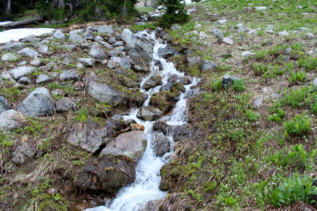
| There was one creek or another running by us throughout most of this hike |
.jpg) |
| Entering the Jedediah Smith Wilderness. |
.jpg) |
| The trail looked like this for miles |
.jpg) |
| Wide open meadows of wildflowers |
.jpg) |
| This is where we decided we didn't need slickers anymore |
.jpg) |
| Some of the adult leaders. I carpooled to kindergarten with the guy who is waving |
.jpg) |
| Aspen gave way to fir |
.jpg) |
| Rocky crags jutted out along the canyon walls |
.jpg) |
| everywhere |
.jpg) |
| Nice and level for a long while |
.jpg) |
| There was a lot of shade on this part of the trail |
.jpg) |
| Boulders unceremoniously dropped by the receding glacier |
.jpg) |
| Bullwinkle |
.jpg) |
| Small trailside waterfall |
.jpg) |
| The sky looked like this until about noon |
.jpg) |
| Everybody had to climb the rock |
.jpg) |
| View of the valley from the rock |
.jpg) |
| Avalanche damage |
.jpg) |
| Cairn marking the trail through the avalanche damage |
.jpg) |
| The second moose |
.jpg) |
| First crossing |
.jpg) |
| Another waterfall |
.jpg) |
| And another |
.jpg) |
| I believe these are called avalanche lilies |
.jpg) |
| My boy at the second crossing |
.jpg) |
| This scout stayed behind to make sure all the old men got across the river safely. Okay, it was more of a creek. |
.jpg) |
| These plants were growing in the rotting log we crossed |
The Trail: Part III
The next section of the trail became more of a brutal slog. The trail got steeper and eventually we came to the cirque or glacial bowl, the place where this glacier originated.
We stopped at a boulder field to catch our breath and one of the scouts decided he had had enough and did not wish to continue. We coaxed and cajoled him, but to no avail. One of the other scouts, though refused to give up on his friend and stayed with him. He told the boy that the hike would not be complete if everyone didn't make it to the top. After ten or so minutes, finally the boy got up and made the determination he was going to go on. I was proud of the other boy though. I saw a young boy learning how to become a man.
At the top of this boulder field were two stones that probably had been a single stone at one time. It appeared to have been cleaved in two by a giant Norse axe. One of the leaders called it the "Gate of Manhood." Sadly, I didn't get a picture of this feature. Once we passed the Gate of Manhood, the trail continued through the forest. There was a narrow stream plunging down the side of the mountain with numerous waterfalls in it's body. One of the scouts climbed next to the waterfall and I followed. We met up with some of the others at the top of that waterfall.
One of the leaders was an elderly gentleman and this trail was difficult for him. He began to lag behind so I stayed with him for the remainder of the trip. You never let anyone hike alone. Rule number one. He slogged on, though and we both made it to the top. But that is later.
We followed a fairly steep trail up to the cirque, around a boulder and through a snowfield where the trail became a series of very steep switchbacks. I estimate from the Gate of Manhood to the rim of the canyon we gained around a thousand feet in elevation. That was about one mile, I think. That was a brutal slog. I will say, though that as hard as it was, it still didn't compare to the misery of the Face Trail. At least there was something to look at.
.jpg) |
| Transition boulder field |
.jpg) |
| The scout who stayed behind to help his friend up the mountain |
.jpg) |
| What the sky looked like |
.jpg) |
| First view of Tablerock |
.jpg) |
| Mini waterfall |
.jpg) |
| Another section |
.jpg) |
| and another |
.jpg) |
| and another |
.jpg) |
| The brink of the mini waterfall |
.jpg) |
| The glacial cirque. Yeah, we had to go up there. In the center of the picture are people from our group |
.jpg) |
| We had to skirt this boulder |
.jpg) |
| An idea of how steep this trail was |
.jpg) |
| Watermelon snow. A fungus grows on the snow at this altitude that supposedly tastes like watermelon. Don't eat it though because it will make the rest of your climb very unpleasant... |
.jpg) |
| The first view of the Grand Teton, peeking out from behind another mountain |
.jpg) |
| The sun finally started to come out |
.jpg) |
| Waxy yellow flowers at 10,000 feet |
.jpg) |
| Honeysuckle or columbine at 10,000 feet |
.jpg) |
| For awhile there was a storm over the Grand Teton |
.jpg) |
| Beautiful view of glacial cirques |
.jpg) |
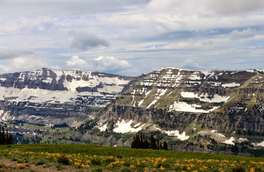
| Tablerock with the Tetons behind |
The Trail: Part IV
Somewhere along the line, someone had taken the older gentleman's pack and traded him for a lighter one. When we were climbing out of the bowl, someone radioed to me that they had left his pack on the canyon rim. When we got to the rim, it seemed that a yellow bellied marmot had found his pack first and had made himself at home with my friend's lunch. The marmot seemed rather unconcerned until we approached to within ten feet of it, then it scurried off.
We did a quick inventory, then my friend sat down and put his pack together, ate a little uncontaminated food and we set off again. The next section of the trail began at the rim and we traversed over snow and broken rocks. At that elevation, the approach to Tablerock appeared to not be very steep. It was a lie. In addition to the trail being steeper than it looked and us being roundly fatigued, we had to navigate snow fields and boulder fields.
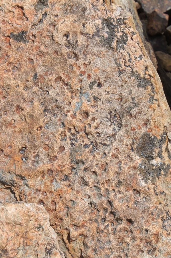
This was all sedimentary rock at this point and one of my geologist friends told me to look for worm burrows, rain impressions and ripple marks in the stone. Check, check and check. After the boulder and snow fields, the trail became much steeper at the final approach to Tablerock
.jpg) |
| The varmint at the backpack |
.jpg) |
| The beginning of the trail at the rim |
.jpg) |
| Beautiful vistas |
.jpg) |
| These were growing at 10,500 feet above sea level |
.jpg) |
| Sedimentary rock. This is why cartographers use cinderblock shapes to indicate sedimentary rock |
.jpg) |
| This is not the place where we climbed up, but it looks an awful lot like it. Gives an idea what we went through |
.jpg) |
| The last section was one of the hardest because our goal was in sight, just out of reach, mocking us. No matter how close we came, it always seemed to be that much farther. |
.jpg) |
| Worm burrows |
.jpg) |
| The trail petered out about here and we had to make our way across the boulder field |
.jpg) |
| Mocking us at the snow field |
.jpg) |
| Fossilized rain impressions |
.jpg) |
| The South Teton (I think) |
.jpg) |
| Getting closer |
.jpg) |
| Cool rock, I'll have my paleontologist friend tell me what this is |
.jpg) |
| Final approach, very steep. About 60 degrees, angle not temperature |
.jpg) |
| Another view of the final approach |
.jpg) |
| Ripple marks |
.jpg) |
| Cairn left for me by my kindergarten friend |
The Trail: Part V
The summit. After the final approach, the summit to Tablerock becomes more of a rock climb. It was refreshing because for the first time on the trail, we were able to use our hands and arms to pull us up rather than relying only on our legs to propel us forward. We climbed to the top and emerged at 11,100 feet above sea level. This is a rigorous hike. It is also one I would like to do again, once or twice.
When I reached the rock climb, I called on the radio to my son and asked him to climb down and guide me up. He did and we made the top. We stayed up on top for a half an hour or so, maybe closer to an hour. Some of the hikers in our group summited much earlier than we did so they got longer on top.
It was a bit windy and mildly chilly, but it was refreshing after the hard sweat we had endured getting to the top. We ate our lunch up there and discovered a colony of marmots that were very friendly, Apparently they had grown accustomed to humans.
.jpg) |
| Rock climb at the summit |
.jpg) |
| Another view of the rock climb through sedimentary rock |
.jpg) |
| The worms must have been frolicking here |
.jpg) |
| I found these flowers at 11,100 feet |
.jpg) |
| The view of the Grand Teton from Tablerock |
.jpg) |
| The view of the Grand and the Middle Teton |
.jpg) |
| My son and I on Tablerock with the Grand Teton in the background |
.jpg) |
| Looking north on Tablerock |
.jpg) |
| Looking into Grand Teton National Park, America's alps |
.jpg) |
| More of the same |
.jpg) |
| My son on Tablerock. Now all of the boys in the family have summited at least once |
.jpg) |
| Asters on top of Tablerock, and not sickly either |
.jpg) |
| Some kind of phlox I believe on top of Tablerock |
.jpg) |
| Glacial valley |
.jpg) |
| Mount Teewinot, I believe |
.jpg) |
| From the north end looking south. Gives an idea how big this rock is |
.jpg) |
| Our group, minus the photographer |
.jpg) |
| I had my short lens on and I didn't crop this photo. Yes I was that close. |
Part VI: Home
After spending the better part of an hour on the rock, we figured we had rested enough and headed back down the trail. Because of how steep it was and the fact that I had already taken over four hundred photos, I decided to stow the camera in my pack for the rest of the hike. I determined only to get it out if I saw a grizzly bear or another moose or something equally as cool. I was exhausted and was glad I didn't have the extra worry of the camera on the way down.
We considered going down the face trail which would have cut three miles off the total, but decided against it because we had to go back to retrieve a pack. I ran out of water on Tablerock itself, so going down the mountain was difficult. My camelbak carried 64 ounces of water and I consumed them all on the way up. Never figured I would have consumed that much water. The hike out was uneventful and I was glad. We reached the parking lot and began the drive home. Part way there, we stopped at a grocer to get a drink of juice and I walked slow and hunched up. I felt older than I really am.
This was a wonderful hike. I loved the Huckleberry Trail. So much better than the face. It was even better because I got to spend a great day with my youngest son in one of the most scenic places on the planet. I have a great life!
No comments:
Post a Comment