Second Failed Attempt at Mesa Falls This Year
We had a little time last weekend, and decided to make a quick trip up to Mesa Falls, Idaho. I wanted to see the falls with snow around them. I dunno, I think it would be pretty. We attempted to see it on Valentines Day and got as far as Bear Gulch and had to turn back because of snow pack on the road. I figured a month and a half would be enough time to get the snow off the road to at least get to Lower Mesa Falls. It was unseasonably warm during the month of March.
We turned East at Ashton, Idaho and headed out along highway 47, which becomes the Mesa Falls Scenic Byway. The road dips down into Warm River Canyon and just before the road climbs up the side of the Island Park Caldera (the largest volcano in the world) there is a small section of river that is closed to fishing. The fish know this. There is a platform built out above the water where people can go feed the fish. The trout right at that spot get very big. Some of them are upwards of two feet long.
We no sooner got to the fish platform when two bald eagles began flying overhead. One was a mature bald eagle and the other was an immature bald eagle. It was very cool. I always like to see the eagles.
Mature bald eagle
Mature and immature bald eagles
Learning to fly
When the eagles' display was over, we then proceeded to feed the fish. I brought along a loaf of bread for this purpose. The Hot Chick threw the bread in the water and I took pictures of some really big fish. When you throw the bread in, it becomes a feeding frenzy. It's a great place to take visiting family members, especially when they have young kids.
Big fish
Reel Big Fish
Feeding frenzy
Breeching...
Like a whale
We proceeded up the side of the volcano and descended into Bear Gulch. On Valentines Day this was as far as we got. From Bear Gulch to Lower Mesa Falls is three miles. The road was clear and dry. We thought we were good. About a mile later, though there was a lot of snow on the road. There were deep wheel grooves in it which meant it was somewhat passable, but I thought only if I had a four wheel drive would I attempt that. My front wheel drive Chrysler Town and Country minivan was not built for those conditions. Discretion being the better part of valour, I decided to turn around and go back. It wasn't a total loss, however because we saw eagles and really big fish.
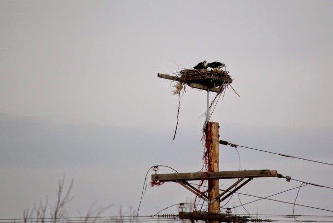
As we headed for home, I saw a sign that looked like a pair of binoculars. That usually means birds. We took that road to the Fun Farm Bridge near St. Anthony, Idaho and drove around through the countryside along the Nez Perce Historic Byway. The Hot Chick pointed out a large nest with two big birds on it. They were osprey. This failed trip was looking up!
Osprey
again
Since we were near the world famous St. Anthony Sand Dunes, we decided to drive out to see them. I wasn't really going to get out and play, I just wanted to check them out in case I wanted to bring the kids and maybe grandkids out later this summer. I remember going to the sand dunes when I was a boy.
According to the magazines that care about dune buggying or four wheeling in the sand, the St. Anthony Sand Dunes right here in southeastern Idaho are the only place on earth that boasts every type of sand feature that enthusiasts like to ride on. That's kind of cool, I think.
So, when the wind erodes the basalt out in the valley, and the wind is omnipresent here in southeast Idaho, the basalt breaks down into two major components. First there is the loess, which gets deposited all over the valley. That is what makes the great potatoes grow here in Idaho. The other component is sand which blows and gathers at the sand dunes in St. Anthony.
The story goes that when the early Mormon Pioneers entered the valley here, the wind was so bad that they camped to wait it out. After one night, some of the men went to Thomas E. Ricks, the leader and said, "Let's pack up and go." He is reported to say, "Why don't we wait until the wind dies down." And that is how Rexburg, Idaho was settled.
One of the dunes
...and another
We'll spend some quality time on the dunes this year, I think. I need to see them again. They cover hundreds of acres, maybe thousands here in the sagebrush steppe that is southeastern Idaho.
So, for not getting to see what we set out to see, it wasn't a bad day. There is really so much to see here in southeast Idaho. I've spent a lifetime here and haven't scratched the surface. This is truly an idyllic place.
Normally, by this time of year, we would have made somewhere between three and five trips to Yellowstone. This year, however, since I was acting in a play, we only made it up once, on Memorial Day weekend. It was the only weekend day I was not involved in rehearsal.
Last Friday, the show ended and I had no obligations to be around on Saturday. We had to wait for my son to get home from Treasure Mountain, Boy Scout Camp where he is a staff member this season. He returned home at about three in the afternoon which meant a Yellowstone trip wasn't going to work. We did, however decide to visit Island Park.
Island Park is a great vacationland on the Idaho side of Yellowstone National Park. It is situated inside the crater of the largest volcanic caldera known to exist on the planet. The community of Island Park boasts the longest main street anywhere in the world. It is around 31 miles in length.
Island Park is truly a wonderland. There is a movement among some groups to make Island Park into a National Monument which would essentially enlarge the borders of Yellowstone. From the time you descend into the caldera until you reach the town of West Yellowstone, you are in a beautiful lodgepole pine forest with rivers, lakes, ponds and springs. There is Harriman State Park, Henry's Lake, a migratory bird refuge, big game animals and several small communities of vacation homes all along highway 20. It is idyllic. Yellowstone gets all the press, but Island Park has plenty to offer.
We decided to visit a couple of the springs in Island Park for our short trip on Saturday.
We took the Mesa Falls Scenic Byway from Ashton, Idaho up through Bear Gulch and past Mesa Falls. One of my neighbors had told me about Warm River Spring which gushes out of the side of the cliff about forty to fifty feet up and cascades down the side of the mountain. We needed to see that one. I wanted to show my boys where rivers come from.
Warm River Spring issues about 200 cubic feet per second of water, and the temperature is a constant 50 degrees all year long. Some rivers will freeze over, but not Warm River. Even when it gets to sub-zero temperatures it doesn't freeze. It's because the water is heated underground from the residual effects of the last volcanic eruption.
In the 1930's, the CCC (Civil Conservation Corps) built a fish hatchery and cabin at the site of Warm River Spring. The hatchery is long gone, but cabin is still there and is available to be rented. The CCC tapped the spring during the great depression and some of the water still pours out of pipes that were put in place at that time.
As I walked past the cabin, I smelled the unmistakable scent of Yarrow. There were hundreds of mature Yarrow plants in the "lawn" in front of the cabin. I like Yarrow a great deal and I don't know if it's a real thing or if it's my imagination, but when I'm hiking and my muscles get fatigued, I crush up some fronds of Yarrow and hold it to my nose and inhale it. It seems to make me have more energy and my muscles to lose some of that tension.
When I was a boy in scout camp, one of the merit badge counselors told me that the Native Americans used to chew on Yarrow for relief of toothaches. It apparently has mild analgesic properties.
Yarrow flowers
Yarrow fronds
The cabin at Warm River Spring
The headwaters of Warm River. Note the two pipes at the top of the spring. Those were installed by the CCC
The water comes out quite rapidly
Drinking from some of the purest water on earth
Apparently it meets the standard. It did seem a little warmish though, but without the sulphur aftertaste you might get in Yellowstone.
The family at the spring so you can see how large it is
The family at the spring
From Warm River Spring, we went to a place called Big Springs, which is near the hamlet of Macks Inn. Big Springs is a different kind of spring than Warm River Spring. Big Springs bubbles up from the ground while Warm River Spring erupts from the cliff face.
On our way over, we stopped for a couple of pictures. One was of an osprey in a nest and the other was of the Tetons.
Osprey on nest
The Teton Range from Island Park
Back in the early part of the twentieth century, a German immigrant named Johnny Sak moved to Island Park and built a cabin at Big Springs. He was only 4'-11" tall. He met a girl in Ashton that he loved and she loved him, so he went to Big Springs and built a cabin for her. It took him more than two years to complete it, and when he went to get her, he found she had gotten married. He lived in the cabin as a hermit for the rest of his life. He made his living by making beautiful, hand crafted furniture from Douglas Fir. He would bury a tree for a year, allow the worms to eat trails through the bark and then he'd dig it up and shave the bark down to the worm burrows and make his furniture from that wood. On another excursion, I'll take photos inside the Sak cabin. By the time we arrived on Saturday the cabin was closed. The workmanship inside is very beautiful.
Johnny Sak cabin
Big Springs is the headwaters of the Henry's Fork of the Snake River. One of the big attractions here is that fish from the hatchery in Ashton migrate up the river and find sanctuary under the bridge. Fishing is illegal at Big Springs and so the trout grow to enormous proportions. There is a machine that dispenses a handful of Purina Trout Chow (yes there is such a thing) for a quarter and you can feed the fish. Seagulls and ducks have found that handouts are a cheap way to get a meal here, and I have in the past seen muskrats.
Sadly, some rotten people came in on snowmachines last winter and killed the fish. I don't know if they were hunting trophies or were eating them or were just rotten people. The fish haven't recovered yet and we only saw a few of them and they were normal size.
Big Springs has a temperature of 52 degrees year round and is not subject to freezing either, the same as Warm River. The water percolates through glacial sediments and volcanic debris. Geologists believe it is water that originates as snowfall and rainfall and absorbs into the ground all over the area and expresses itself at Big Springs.
It is about six miles off the main road, so it never seems to be crowded. My parents used to take us there when we were little kids. I have made sure to take my kids there as well.
The headwaters of the Henry's Fork of the Snake River, Big Springs
Me being bald
The hot chick and I at the headwaters of the Henry's Fork
Spider making a living at Big Springs
Beautiful view along the trail
Random boulder. I like rocks, so it was a natural shot for me to take
The pumphouse that Johnny Sak built
Seagull far from home
And his brother
I was trying to take a picture of the fish in the river and what I ended up taking was a picture that looks like a watercolor. My personal favorite picture of the day. Totally serendipitous.
View of the spring from the bridge
It was a very nice half day trip. One that I'd like to make again. There are a few trails at both Warm River Spring and Big Springs. We didn't take them this time for lack of time and the fact that I injured my ankle awhile ago and it hasn't healed all the way. We will take the trails in the future though. We truly live in a magnificent part of the world.
The Idaho sky. Not quite as big as Montana's, but big enough
I took a hiatus from blogging for several months. I won't go into any details, but life got in the way and the wagons had to be circled for awhile. Time to catch up.
Last fall, my son had a campout at a place called Sand Creek. It worked out that I was able to go with him. I like to go with my sons on campouts as often as I can. Sand Creek is about thirty miles north of where we live, near Ashton, Idaho.
The campsite is situated on the flanks of the largest volcano in the world, the Island Park Caldera. Essentially, if it ever decides to erupt in an explosive style again, we live in the 100% kill zone. Everything, including bacteria would be wiped out where we live. We'd have just enough time to kiss our backsides goodbye. It isn't the tallest volcano, but it's footprint is. Before the last eruption, this volcano made Mount Rainier look like a wannabee. Geologists say that when it blew up the last time, the top two thirds of the mountain disappeared. The eruption was so violent that pieces of the mountain ended up in orbit around the planet, and there have been samples of it collected as far away as Israel. This is a big deal.
When we arrived at the campsite, it made me think that this area was at one time a ranch that had reverted back to forest service or BLM control. They had made it a wild bird refuge. There was an old ranch house where the caretaker lived and a few fields of sunflowers and other crops to entice nesting birds to come and stay.
The campsite is situated around several manmade ponds. I believe they were placed there to be watering holes for the cattle. Today they host many varieties of waterfowl in the springtime.
One of the ponds
We arrived around five or six o'clock and began setting up camp. When the tents were set up, the boys immediately went to the pond and began fishing. One boy caught a fish, but otherwise the whole group was skunked.
Camp
The flanks of the largest volcano in the world
The one and only fish
A hapless fisherman
While we were eating, we watched an electrical storm progress steadily towards us. It was pretty eerie and cool all at the same time. I figured it was about thirty miles away at that point.
There was an interesting astrological phenomenon that night. When the moon rose, it was considered a "Blue Moon". Apparently it was the second full moon in a single month. It is very rare and the term, "Once in a blue moon" was coined because of it.
Later that night, as we lay in the tents, the lightning would flash and I'd count the seconds to see how close it was. When it was within a mile, I told the other leaders and the boys to get into the cars, which we did. We waited in the cars for about an hour, waiting for the lightning to pass. When it finally did, we went back to the tents.
The lightning passed but later that night we were subjected to torrential rains. My tent has waterproofing on it, but even that wasn't enough to repel all the water. The tent grew saturated and we got very wet.
Lightning strike
Another one
The "Blue Moon"
Dinner--My boy is the one in the skull shirt
The next morning, we struck camp. One of the boys refused to get out of his sleeping bag, so the boys dragged the sleeping bag out of the tent with him in it. He stayed in the bag, they all went fishing. I went exploring.
There's a boy in that bag
My son and my friend fishing
One of the most beneficial plants in the wild. If you know how to use a
cattail, you can survive most things. They can supply nourishment, insulation, the leaves
can be woven to make mats or baskets, fuel. Great plant.
I don't know what plant this is, except that it is most likely poisonous. The old scout rhyme comes to mind,
"Leaflets three,
Poisonous tree.
Berries white,
Poisonous sight."
Still waters, beautiful reflection
Again
The old footbridge
When it became apparent we weren't going to catch any fish, we opted to return home.
On the way home, I spotted a hillock with a half a dozen or so large cairns on it. We stopped and my son and I went exploring. I like cairns and have built them in the wild on several occasions.
Cairns
Cairns
Cairn
My son next to a cairn to show scale
I have no idea what the cairns were marking. I don't know if they were covering remains, marking a trail or just as a monument to an unknown builder. What I do know is they were cool and I needed a picture of them.
This was a fun campout, even though we got rained on, we didn't get rained out. I'd like to visit here in the spring when the migratory birds are nesting.
.jpg)
.jpg)
.jpg)
.jpg)
.jpg)
.jpg)
.jpg)
.jpg)
.jpg)
.jpg)
.jpg)
.jpg)
.jpg)
.jpg)
.jpg)
.jpg)

.jpg)
.jpg)
.jpg)
.jpg)
.jpg)
.jpg)
.jpg)
.jpg)
.jpg)
.jpg)
.jpg)
.jpg)
.jpg)
.jpg)
.jpg)
.jpg)
.jpg)
.jpg)
.jpg)
.jpg)
.jpg)
.jpg)
.jpg)
.jpg)
.jpg)
.jpg)
.jpg)

.jpg)
.jpg)
.jpg)
.jpg)


