.jpg) |
| The Absaroka Mountains |
We have had a busy summer, Rhys had scout camp, Haydn had band camp, Haydn, Chimene and I had the pioneer trek. It has been very busy. My youngest sons have been after us to go camping all summer. We decided that it was time to do so last week.
I started exploring things to do and areas to visit and found a site that I had wanted to visit for some years. The Tom Miner Basin in southern Montana is home to a huge petrified forest. There is an interpretive trail through a small portion of the petrified forest and at the end it's allowable to collect with a permit. Since I've been a rockhound all my life, and my boys like that sort of thing too, it seemed like a natural fit. The campground and trailhead is about thirty miles northwest of Gardiner, Montana, and the ranger station for the permits is in Gardiner. Our original plan was to camp for two nights in the Tom Miner Campground and on the second day we were going to do the interpretive trail in the morning and climb Ramshorn Peak in the afternoon, then we planned to spend the third day in Yellowstone. We had to register all three of our sons in school on Thursday so we didn't get out of town in enough time to get to the ranger station for the permits so we changed our plans on the fly. Here's the account of our trip.
Day One:
In order to get to the Tom Miner Basin from where we live, we had to travel through Yellowstone National Park. Our route started in southeast Idaho and went to West Yellowstone, Montana. From there we went to Madison Junction and on to Norris. From Norris we travelled to Mammoth. By the time we arrived in West Yellowstone, we knew we would not make it to the ranger station in time. We started exploring our options and thought I could either get up early the next day and drive back to Gardiner to get the permits and then drive back to Tom Miner which would have added an hour and a half of extra driving that day, or we could find a campsite somewhere closer to Gardiner. Chimene started looking at the map and found a campground called Indian Creek Campground near Sheepeater Cliff in Yellowstone.
I have lived near Yellowstone for around 35 years and until last Thursday I had never spent the night there. It had been on my bucket list for quite some time, so we decided to take our chances. In Yellowstone, during the tourist season, campgrounds are notorious for filling up by nine o'clock in the morning. We happened to go camping on a weekend that the park wasn't quite so busy and we found an open spot. We set up camp and just enjoyed each others company until bedtime. We foraged for wood, built a fire and read books. It was pleasant.
.jpg) |
| Indian Creek Campground |
.jpg) |
| Indian Creek |
.jpg) |
| Garrett foraging for firewood |
.jpg) |
| Haydn foraging for firewood |
.jpg) |
| Rhys building a fire |
.jpg) |
| Camp |
.jpg) |
| Had to go all the way to Yellowstone to read books |
Day Two:
We woke up with the sun on Friday and built a fire and made breakfast. Camp food doesn't have to be bland, so we had omlets in a bag. Here's the recipe:
Take a quart size freezer bag and write your name on it with a sharpie or ballpoint pen
Add two or more eggs
Add toppings. We brough onions, green peppers, bacon, mushrooms and cheese.
Close the bag and squish the contents with your fingers until thoroughly mixed
Put the bag in a pot of boiling water until the eggs are cooked
Roll the omlet out of the bag on a plate and voila. Breakfast
Quite good actually.
.jpg) |
| Omlets ready to cook |
.jpg) |
| Omlets cooking |
.jpg) |
| Finished product. The dark specks are pepper, by the way |
We struck camp and as we were leaving we saw a raven in camp. This one was acclimated towards people and was quite unconcerned when I started following him to get his photograh. The ravens in Yellowstone are some of the largest I have ever seen. In West Yellowstone, we called them "Dumpster Chickens" because they were always making their living around the trash cans. Some of these birds are fifteen inches tall. Big ravens.
.jpg) |
| Big raven in camp |
We drove through Mammoth to Gardiner and stopped for the permits, got directions and went on to the Tom Miner Campground. When we arrived, we drove around and found our campsite. The campground only has thirteen sites, and there is plenty of room between them. Each campsite is very private. We hardly saw our neighbors, unlike camping at Indian Creek the night before. In Yellowstone, every square inch of the campgrounds is used for campsites it seems.
I found a campsite adjacent to the creek with a large fallen log as a bridge. Instinctively I knew it was the right campsite for our boys. Rhys and Garrett spent what seemed like hours crossing that log and exploring around the creekbed. I have had great luck in the last two years with forest service campsites. I am a fan. I liked this campsite better than Indian Creek, and I did like the Indian Creek Campground. We got the tent set up and ate lunch. Because we had stayed in Yellowstone the night before, we had to forego the Ramshorn Peak hike. Next time we'll get it.
.jpg) |
| Tom Miner Campground |
.jpg) |
| Where Rhys and Garrett spent most of their time in camp |
.jpg) |
| Haydn in solitude |
.jpg) |
| Chimene, the hot chick at the creek |
.jpg) |
| The old man in camp |
.jpg) |
| Idyllic |
After lunch, we set out to the petrified forest. The trail is about two miles one way with about a thousand feet of elevation gain. Most of the gain is by switchbacks so it isn't a strenuous climb. It was fairly easy. The first portion of the hike is across the valley bottom, then it begins to ascend one side of the canyon. The trail is interrupted by seven interpretive signs telling about the events that created the fossil forest.
Depending on which scientists you believe, the Gallatin Petrified Forest is either two forests on top of each other or up to 26. It all has to do with the positions of the trees. They have found 26 layers of trees up there, but continue to argue about how the trees were deposited. The point of contention is that up to 70% of the forest is still vertical. I'm not going to go into the geology of it that greatly, for me it doesn't matter which group of geologists is right, it was just dang cool. Suffice it to say that the forest was petrified during the Eocene period of geologic time and it was created by successive volcanic eruptions. Two to twenty-six is quite the disparity. I'll leave it to the professionals to sort out.
The first interpretive signs talked about the geology and what one might find as they advanced along the trail. Much of the rock was volcanic conglomerates, where host country rock was combined with volcanic ash which then solidified. Within this congomerate ash is found great examples of petrified wood.
The first wood I saw was a hollow limbcast embedded in the side of a cliff. The limbcast was essentially a very long geode full of quartz crystals. I poked my hiking stick down the hole and found that it was about four feet deep. Luckily for us, collectors had not removed the crystals from this limbcast and it was basically intact.
Along the trail, one sign pointed out a vertical tree trunk sticking out of the overhang of the cliff. There were several other tree trunks, branches and roots, some vertical and some not
in situ all over the site. It was inspiring. One of the signs along the way told of uncontrolled collecting years ago that destroyed a great deal of the site and requested restraint in future collecting. The annual amount that is allowed to be collected now is twenty cubic inches, or basically a piece the size of a human fist. I was okay to collect only that much. Chimene was the first to find a piece, and once we figured out what we were looking for, it was everywhere. I'll go back to this site again.
.jpg) |
| At the trailhead |
.jpg) |
| The trail through the valley |
.jpg) |
| Looking back down the trail at the Absarokas |
.jpg) |
| The first example of petrifaction was up here, at around 9000 feet |
.jpg) |
| Another outcropping with petrified wood, also around 9000 feet above sea level |
.jpg) |
| Magnificent views of the Absarokas |
.jpg) |
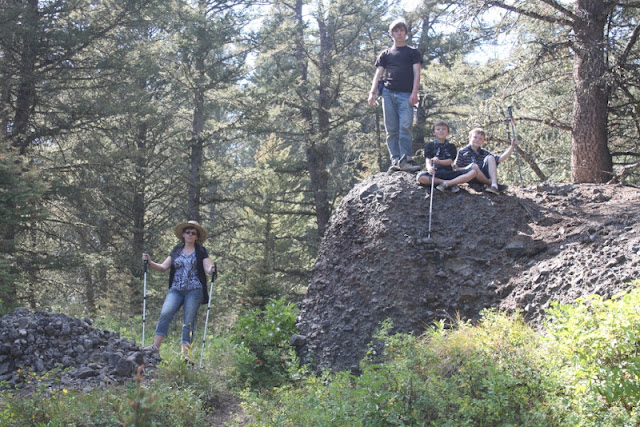
| The fam on the conglomerates along the trail |
.jpg) |
| How steep the mountainside is along the switchbacks |
.jpg) |
| Boundary between rock layers. Softer more eroded layer on the bottom |
.jpg) |
| The boys always seem to find a cave |
.jpg) |
| Rhys posing |
.jpg) |
| Limbcast full of quartz crystals |
.jpg) |
| Vertical treetrunk in cliff overhang |
.jpg) |
| Closeup of treetrunk |
.jpg) |
| Branch or root in situ |
.jpg) |
| Some steep terrain |
.jpg) |
| Cool horizontal log in situ under a cliff overhang |
.jpg) |
| The hot chick being bad. It's about 500 feet of sheer drop behind her |
.jpg) |
| Where I found my best piece |
.jpg) |
| Our haul. We only took about half of what we were permitted to take. It was enough |
We headed back to camp, built a fire and made dinner. Then the boys explored some more and then we settled down and read until after dark. This was a very relaxing time, by the way. It was nice to be out in nature with nothing to do, and no deadlines to attend to. My Dad had a saying he used to tell newlyweds. He said, "The secret to a happy life is to make beautiful memories." This whole trip was a beautiful memory for us.
.jpg) |
| Back at camp. I like this photo |
Day Three:
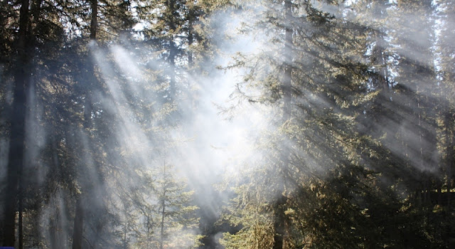
Once again, we awoke to the sun. This campsite was very pleasant. The creek running through camp was musical and soothing. We had breakfast and then struck camp. We weren't in any big hurry to do so. We enjoyed ourselves here. We built another campfire, and the wood was a bit damp and created some great smoke. As the sun rose, it created great shafts of light through the camp. Couldn't help it, had to take pictures.
.jpg) |
| Second best picture from the trip |
.jpg) |
| Best picture from the trip |
After we broke camp, we went back into Gardiner and then into Yellowstone. In Gardiner, we stopped because there were half a dozen young elk, some still with spots on their coats grazing in someone's yard. I don't normally photograph elk because I've seen tens of thousands of them in my lifetime, but I rarely see them with spots on so it was a good photo op.
When we got into Yellowstone, we headed over to Lava Creek Picnic Area for the trailhead to the brink of Undine Falls. We had only seen Undine Falls from the pullout on the road before. I wanted to see it from a different angle. It was truly magnificent. The trail goes for about a mile through a sagebrush plain, nearly level until you reach the brink of the falls. We did a short rock climb down to the brink. The trail continues down to the Mammoth Campground and we took it for another mile or so and then turned back. We had other things we wanted to do that day.
.jpg) |
| Spotted elk in someones' yard |
.jpg) |
| The Roosevelt Gate at the North Entrance to Yellowstone National Park |
.jpg) |
| This gives you an idea about where we were |
.jpg) |
| Really cool mountain |
.jpg) |
| On the trail to Undine Falls |
.jpg) |
| At the brink of the falls |
.jpg) |
| Lava Creek just before the falls |
.jpg) |
| Undine Falls from the other side |
.jpg) |
| I thought this rocky promontory was pretty cool along the cliff face |
.jpg) |
| I came across some Dalmation Toadflax. This is a non-native, invasive species from Asia, by the way. Pretty but not a good plant for our environment. Was introduced in the 1870's and has spread out through the west. Part of the Snapdragon family |
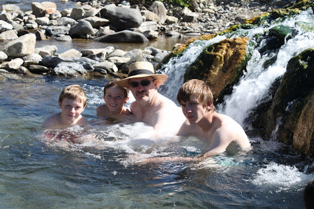
The rest of the day was just peat and repeat. Things we have done before and things I have blogged about before. First we went to the Boiling River. We have to do that every year now. The younger boys insist and I don't put up a fight. It reminds me of my younger days when I used to go hot potting in the dead of night in Yellowstone. Hot potting is when you go into the park late at night and skinny dip in the hot pools. I don't skinny dip anymore and I don't go in the hot pools. It's illegal and I haven't done it since the late 1970's. I got caught in an illegal one, and ticketed, but that's another story.
The Boiling River is a place where hot discharge water mixes with a cool running river and creates a nice place to soak after a long day of hiking. It is legal here, and very soothing. I really enjoy going to the Boiling River. It's about a third of a mile hike to the site. The Park Service has erected fences and stairs into the water at several spots. I would recommend the Boiling River to anyone who likes a good hot tub soak.
After the Boiling River, we had to stop at Sheepeater Cliffs. We like to climb them at least once a year. That's another thing my kids always ask to do each season. There is a picnic area there and it's our favorite place to have a picnic in Yellowstone.
.jpg) |
| The fam at the trailhead to Boiling River |
.jpg) |
| Ye Olde Swimming Hole |
.jpg) |
| Dad and boys and pasty flesh at the Boiling River |
.jpg) |
| The hot chick at the Boiling River |
.jpg) |
| Extinct thermal feature at the Boiling River |
.jpg) |
| Garrett climbing Sheepeater Cliff |
Indian Creek Campground--$12
Tom Miner Campground--$7
Gas--$45
Beautiful Memories--Priceless
.jpg)
.jpg)
.jpg)
.jpg)
.jpg)
.jpg)
.jpg)
.jpg)
.jpg)
.jpg)
.jpg)
.jpg)
.jpg)
.jpg)
.jpg)
.jpg)
.jpg)
.jpg)
.jpg)
.jpg)
.jpg)
.jpg)
.jpg)
.jpg)
.jpg)
.jpg)
.jpg)
.jpg)
.jpg)
.jpg)
.jpg)
.jpg)
.jpg)
.jpg)
.jpg)
.jpg)
.jpg)
.jpg)
.jpg)
.jpg)
.jpg)
.jpg)
.jpg)
.jpg)
.jpg)
.jpg)
.jpg)
.jpg)
.jpg)
.jpg)
.jpg)
.jpg)
.jpg)
.jpg)
.jpg)
.jpg)
.jpg)
Great blog post. Just stumbled across this, as my friends and I stayed in that same area last summer. So beautiful up there, and I truly love your attention to detail, features, naming--it very much appeals to me!
ReplyDeleteThank you Matt
ReplyDeleteHow much are the permits?
ReplyDeleteHeading to Yellowstone this Saturday. I've read about some of these places...I've added several of your stops to my list!...thanks for the fun blog!
ReplyDeleteI LOVED reading this. Your wife is, indeed, hot! I love that you call her that. HAPPY!
ReplyDelete