 |
| Grand Canyon of the Yellowstone |
It had been two weeks since I had been in Yellowstone. I was jonesing. I convinced the Hot Chick to head out with me for an excursion. Her favorite spot in Yellowstone is Canyon, so that ended up being part of the negotiations.
Our plan was to head straight up into Canyon and see it from places we hadn't been for a long time. A couple of years ago, we did most of the South Rim Trail with the exception of Uncle Tom's Trail. That's the 300 step, iron staircase that heads about halfway down the canyon. It's a beautiful view, but it's daunting. That was going to be on our agenda for sure. When we were there a three weeks ago, I noticed a small waterfall behind the staircase of the Uncle Tom Trail. Since we like waterfalls, we decided we needed to do the Uncle Tom Trail sometime this summer. We also noticed another small waterfall at Red Rock Point that we needed to see first hand. Our work was cut out for us.
 |
| Uncle Tom's Trail, shot taken three weeks ago from the brink of the falls trail |
When we were done with Canyon, the Hot Chick decreed we were going to go over the Dunraven Pass into Tower, over to Mammoth and home from there. Sounded like a good plan to me.
Leg #1: Virginia Cascades
Most of our excursions to Yellowstone begin in West Yellowstone at the West Entrance. It's the most convenient entrance to our home in Idaho. Occasionally we will enter the park from the south when we visit Grand Teton National Park first.
The road from West Yellowstone to Madison Junction is a beautiful stretch of road that alternates between lush forest and open meadow, and always the Madison River is present. For the first seven miles the river is on the left and then, after the aptly named Seven Mile Bridge, the river is on the right for the rest of the time. Between West Yellowstone and Seven Mile Bridge, we rarely see mammals, but almost always see birds. Eagles, Vultures, Canada Geese, Swans and Osprey are frequent visitors along that road. My friend, Jeff who is a winter snowcoach tourguide says the large mammals favor that area during winter but move on in spring and summer.
Yesterday (Saturday) we saw two Osprey along that section of road. The first one was in a tree on the other side of the river. The second one was perched on it's nest near the road. That nest was originally a bald eagle nest and a couple of years ago it was hijacked by Canada geese. The eagles moved on and the geese nested there for a couple of years. This year, the new residents have moved in, the osprey family. I got a few great shots of them.
 |
| Osprey in the tree across the Madison River |
 |
| Osprey in the Eagle/Goose/Osprey nest |
On most of the sections of highway through the park there are side roads that are always nice to go on. From West Yellowstone to Madison Junction there is the Riverside Drive which is part of the old road that skirts the Madison River. I sometimes see elk along that road early in the season. Between Mammoth and Tower is a six mile drive called the Blacktail Plateau Drive. Between Madison and Old Faithful is the Firehole Falls Drive, the Fountain Flats Drive and the Firehole Lake Drive. Between Norris and Canyon there is a short drive called the Virginia Cascades Drive. We have only taken that a few times but as we were heading down that road, the Hot Chick asked if we were going to do the drive and that sounded like an invitation to me.
I think the drive is two miles long. I noticed a little turnout in the first thousand yards of the drive and pulled off to see what it was. Ends up being a trailhead along the river. Next time, I think we'll take that trail and see the falls from a different point of view.
The road passes a series of hoodoos after the first view of the falls. The Virginia Cascades is a sixty foot cascading waterfall along the Gibbon River. It's pretty enough that they carved a road out for visitors to see it. I recommend seeing it at least once. The waterfall is at the end of the road and just before the road joins up with the highway it passes by a lush meadow that looks like perfect moose habitat. I have never seen a moose there but I think I will someday. It's a favorite spot for fishermen as well.
 |
| First good view of Virginia Cascades |
 |
| Hoodoo |
 |
| Hoodoo |
 |
| Hoodoo |
 |
| Hoodoo, yeah that really is a correct term |
 |
| A passing motorist snapped this pic of the Hot Chick and I at the brink of the Virginia Cascades |
 |
| Looking upstream from the brink |
 |
| Virginia Meadows, pretty good moose country. |
Leg #2: Canyon Village and the North Rim
We stopped at Canyon Village for a moment and went into the visitors center. The National Park Service has done a great job in recent years of creating interpretive materials and making improvements to the major attractions of Yellowstone. The exhibits are informative and interesting. I also think they have done this as part of the attempt to keep the majority of park visitors in the high traffic areas. The backcountry of Yellowstone is still nearly pristine, and while I don't think they want to keep everyone out of it, I think they want to limit the number of people who go back onto the trails. Most hardcore hikers aren't vandals and most of us treat the wilds with the respect it deserves. I am all for what the Park Service has been doing.
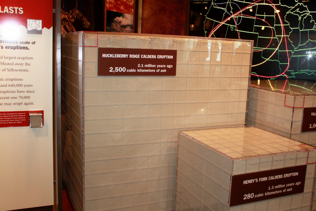
The museum at Canyon has a great exhibit of the three major caldera eruptions as compared to the eruption of Mount St. Helens in 1980. This gives you an idea of just how insignificant the Mount St. Helens eruption was and how catastrophic the three caldera eruptions were. At least one of the eruptions caused an extinction event in Nebraska. This is a significant volcanic hotspot.
They took plexi-glass cubes and filled them with ash to give a scale comparison of each of the eruptions with interpretive materials convenient to them. Basically, Mount St. Helens expelled a cubic mile of ash. See how that compares to the Three major caldera eruptions.
 |
| Mount St. Helens |
 |
| Henry's Fork Caldera. The red cube on the top right represents the volume of Mount St. Helens |
 |
| Yellowstone Caldera |
 |
| Henry's Fork Caldera. I believe this was the largest caldera eruption in the history of the world. |
 |
| This is all of them together for scale. Note how wimpy Mount St. Helens was |
They also have a huge topographic map of Yellowstone with interactive light and sound shows. Well done, NPS.
 |
| Topographic map as viewed from the second floor |
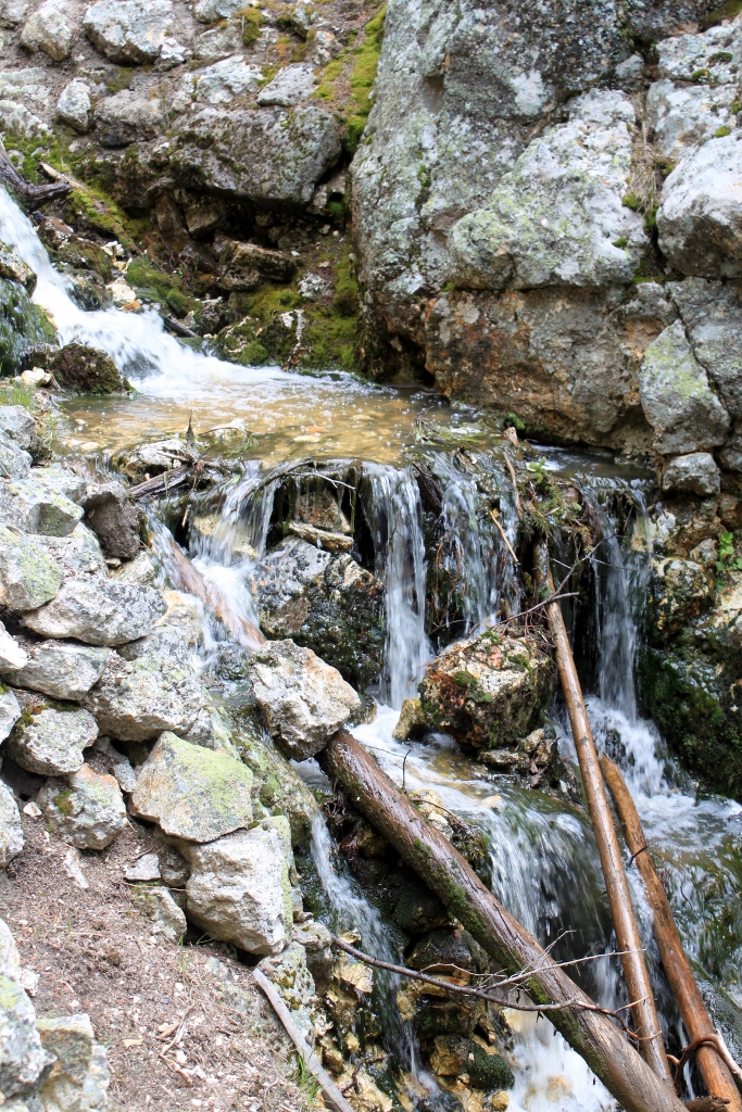
We then continued along the North Rim to Red Rock Point. We had flirted with the idea of going down there with our friends a few weeks ago but we had already hiked down to the Brink of the Lower Falls Trail that day and we didn't have time for much more. The Hot Chick and I decided we needed to hike the Red Rock Point Trail another day. Yesterday was another day. There was a pretty little waterfall along the trail and I'm not sure if it is a permanent waterfall or a seasonal one.
The trail descends quite a way into the canyon by way of switchbacks and stairs. The view of the Lower falls from that trail was spectacular.
When we arrived at the parking area there was a magnificent large raven seated on a fence post. I love ravens and when I saw him I had to have his pic. He posed and preened for me. He has been acclimated to humans so he was unconcerned by me. I didn't get uncomfortably close to him, but much closer than a completely wild raven would have let me. When I was done photographing him I told him thanks and said he was magnificent. I said that outloud. Weird.
 |
| Magnificent raven |
 |
| Another view |
 |
| View from the trailhead of Lower Yellowstone Falls |
 |
| Part of the mini-waterfall along the trail |
 |
| Another part |
 |
| The canyon walls look like this alot |
 |
| Lodgepole pines have a shallow root system. This one has a boulder lodged in it's roots |
 |
| Lower Falls from the observation deck at the bottom of the trail |
 |
| There was a random waterfall on the other side of the canyon |
 |
| What the trail looks like for part of it |
 |
| Spectacular view looking opposite the falls |
 |
| More water in motion |
 |
| Mossy |
 |
| The Hot Chick at a convenient stopping place along the trail. |
 |
| I was there too along with my awesome skull belt buckle |
 |
| From the North Rim |
I have become an old man. We decided to go to the brink of the Upper Falls because we were there and we hadn't been for a few years. As I got out of the car there was a large raven prancing about. It was obviously not bothered by me because he hung out and posed. As I was snapping his photo, a couple of teenage girls ran up and tried to scare him. They were whooping and charging. The raven got out of their way but didn't fly away. I pulled the camera down and said kind of sternly to them, "It isn't nice to scare the birds. And it is especially not nice to scare them when someone is trying to take a picture of them." The Hot Chick heard me and I looked at her and said, "I think I've become an old man."
 |
| The other raven |
 |
| again |
Brink of the Upper Falls
 |
| Water detail |
 |
| Just upstream of the Upper Falls |
The trail to the brink of the Upper Falls follows the old road. It's only a walking road now. Motor vehicles no longer drive on it. We had never walked on it before so we decided to see where it went. It skirts the river and eventually crosses the old Canyon Bridge. We'd seen the bridge before but had never been on it. Since we always want to do things we have never done before, we went.
Along the way, there was a huge boulder that had fallen in the river and naturally we decided to climb on it.
 |
| Small pools near the boulder in the river |
 |
| The old Canyon Bridge |
 |
| Water in motion |
 |
| The Canyon Bridge |
 |
| The Canyon Bridge |
 |
| Decay |
 |
| More boulders in the water |
 |
| The Chittendon Bridge |
 |
| Structure of the old Canyon Bridge |
 |
| Fungus on the trail |
Leg #3: The South Rim and Uncle Tom's Trail
Our next stop was the south rim. I did stop to get some pictures of the glacier lilies that were in bloom. Thousands of them. Pretty little flowers. They were all along the roads near the forest. They didn't seem to be around the marshes or the meadows. Dandelions had taken over there.
 |
| Glacier lily |
 |
| Glacier lily |
 |
| Glacier lilies |
We headed to Uncle Tom's Trail and on the interpretive materials at the trailhead there was a picture of a young ranger in 1936. Turns out it was Gerald Ford who later became President of the United States. He added 18 or 19 properties into the National Park system while he was president. That was cool.
Uncle Tom's Trail is an iron staircase that descends into the canyon at the base of the Lower Falls. There is immense power of falling water there. It's a view you can only get by working for it. It was worth the trip. I think there are something like 300 stairs. That is a lot of stairs! Halfway down, the stairs pass the other mini-waterfall. As I stopped to view the falls, I saw some movement and saw that it was a water ouzel, or an American dipper. That is the same kind of bird we saw in Glacier National Park last summer that would sit at the water's edge and dive into the rapids and find something to eat and come back up with it in it's bill. Crazy bird.
When we made it to the bottom, there was a man from England, and a couple from France that were travelling together. We made friends and talked for about a half an hour. I was able to tell them a few things about Yellowstone. They seemed appreciative.
 |
| Waterfall in it's entirety at Red Rock Point |
 |
| A bold varmint |
 |
| Obviously acclimated to humans |
 |
| Weird fungus |
 |
| More fungus |
 |
| Waterfall along the trail |
 |
| The Ouzel |
 |
| View of Lower Falls from the bottom of Uncle Tom's Trail |
 |
| The stairs literally go around the mini-waterfall |
And then it began to rain.
Leg #4: The Road Home
There was only a 20% chance of rain forecast. This time of year, 20% is almost a guarantee. I was expecting scattered showers but it really became more torrential at times. We headed over the Dunraven Pass to Tower and on over to Mammoth. I think it was because we didn't want to go back the way we came. If I had it to do over again, I think I'd have headed south and gone into Grand Teton National Park.
We saw the sow black bear and her two different colored cubs sleeping near tower. It was the same family we had seen a couple of weeks ago. This time they weren't really interesting because they were sleeping. We also saw a fourth black bear between Mammoth and Tower but he was heading into the woods and we couldn't get a decent shot.
We headed back to West Yellowstone and visited with our friends, the Carters for an hour or so and headed home. We left West Yellowstone just in time to catch an epic sunset. The rain didn't bother me much. We had already had an epic day before it started. The ride home was very rainy but otherwise uneventful. It was a great day.
 |
| A couple of young bull elk |
 |
| Hanging out with an older one. |
 |
| Sleeping bears |
 |
| Obligatory bison shot. I did not crop this picture |
 |
| What the mountains looked like on the way out. This is shot in color not black and white. |
 |
| Epic sunset. |


Love your blog!!!
ReplyDelete